The Genesee River in the Finger Lakes
PART 5-GENESEE VALLEY PARK TO LAKE ONTARIO
Part 1-Location and Physical Features
Part 2-Fillmore (Allegany County) to the Mt. Morris Dams (Livingston County)
Part 3-Mt. Morris (Livingston County) to the State Route 253 Bridge in Scottsville (Monroe County)
Part 4-Black Creek to Genesee Valley Park
Boating
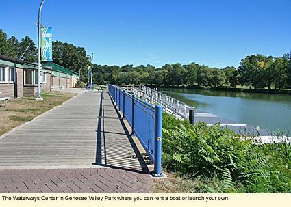
This section begins at the Genesee Waterways Center in Genesee Valley Park at 149 Elmwood Avenue near downtown Rochester. The GWC rents canoes and kayaks but permits the launching of your own boat at no charge.
From the Waterways Center, you can paddle up- or downriver. If you paddle upriver, you can connect with the Erie Canal and take it either east or west. If you paddle downriver, your trip will be relatively short as you will eventually come to a dam/waterfall.
You could easily spend the entire day in the park. It has ball fields, a golf course, tennis courts, paved hiking/biking trails, and picnic facilities. The hiking/biking trails connect with the trail along the Erie Canal and the Genesee Valley Greenway trail. There is also a pedestrian bridge over the Genesee that allows hikers/bikers to cross over the river to use both sides of the park. Just off the campus of the University of Rochester, the park is always busy and quite safe.
The river runs under the Elmwood Avenue bridge, past the University of Rochester on the east bank and continues north to downtown Rochester.
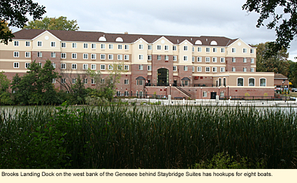
On the west bank is Brooks Landing Dock, a city-operated facility. The concrete landing has no ramp for launching motorboats, but might be able to accommodate the launching of canoes and kayaks, depending on the water level and the agility of the boater. The dock has electrical and water hookups for eight boats. For more information about length of dockage and access to the hookups, call 585-428-6771. The landing dock is directly behind Staybridge Suites, a hotel. Parking is on the south side of the hotel.
Pass under an unnamed pedestrian bridge, and you will find a canoe/kayak launch on the east shore. This short aluminum dock is located just across Wilson Boulevard from the University of Rochester's Gilbert Hall. There is on-street, metered parking. (See campus map)
The next launch site is just downriver north of the Ford Street Bridge in Genesee Gateway Park. The city considers this a canoe/kayak launch site, but you must launch by lifting your boat over a railing to the water below and going down the concrete wall via a ladder. There is an easier launch site across the river at...
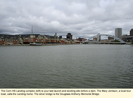
Corn Hill Landing (290 Exchange Boulevard). Besides the long, long concrete landing, which can accommodate many boats, there is an aluminum dock for launching canoes and kayaks. (There is no ramp for motorboats.) Parking is just south of the building complex toward the southern end of the landing and is marked as parking for the launching of boats. The portage is just a matter of a few feet. This is the last launching and docking site before the first electric generating dam. You cannot got north from here.
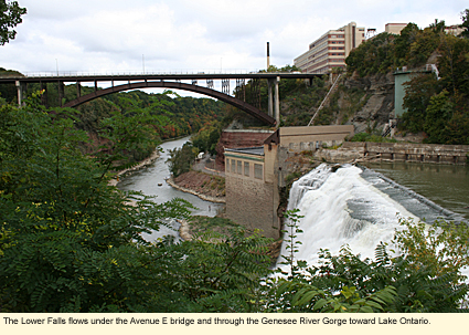
The Genesee River now flows north over an electric generating dam, under an aqueduct , under a number of bridges, and over a beautiful waterfall--the Upper Falls--then through another electric generating dam and over the Lower Falls. (The Middle Falls no longer functions due to the second dam.)
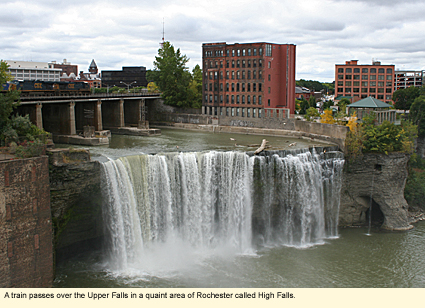
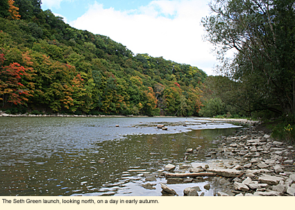
Just below the Lower Falls is the Seth Green launch site on the Seth Green Trail. To access this site, turn onto Seth Green Drive from St. Paul Boulevard. On the left will be a parking lot, and, at the rear of the lot, a closed gate to prevent cars from going down the paved road. (Please read all signs.) You must walk down the paved road and follow the gravel trail a short distance along the shore where you can launch your boat. From the parking lot at the top of the gorge to the shore at the bottom of the gorge, the distance is about .2 mi./.3 km. You should take a look at the layers of rock on the gorge wall on your left as you pass by as each has its own distinct color. Once you've launched your boat, you'll find that the view of the Lower Falls from the water is quite spectacular.
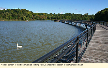
Head north all the way to a widewater called Turning Point. Here you can dock temporarily, walk the boardwalk, and enjoy nature. (See also LowerFalls.org) Then continue north under the Colonel Patrick O'Rorke Memorial Bridge to the last launch site before the Genesee enters Lake Ontario.
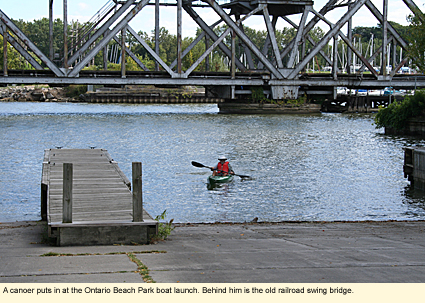
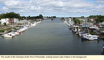
Ontario Beach Park has a large launch site on the west bank with three concrete ramps and two wooden docks. It's at the southern end of the Port of Rochester terminal in which are eating and toilet facilities. During the busy season, a launch fee is charged. This is the principal public launch site for boaters wishing to access the lake and the only public launch site for motorboaters wishing to access the north end of the river. (There are private marinas all along the north end of the river.) Ontario Beach Park is a county park that offers supervised swimming on a sandy beach, a bathhouse, picnic facilities, ball fields and courts, and a carousel. The old Charlotte-Genesee Lighthouse is on a hill overlooking the parking lot. It is open to the public and can be accessed from Lake Avenue.
Whitewater Classification
This section of the Genesee has no whitewater classification.
Water Level
Streamflow Conditions
Wildlife
Until you get to the Port of Rochester, most of the gorge area on both banks is wild. You will find a wide variety of wildlife, including small mammals like squirrels, chipmunks, raccoons, skunks, opossums, and woodchucks. Deer and foxes are probably the only large mammals you will see. Around Turning Point, you will have the opportunity to see many reptiles and amphibians. Birds are abundant here as well. There is a resident pair of non-native mute swans (Cygnus olor), some mallards, green and great blue herons, great egrets, bitterns, kingfishers, gulls, and a variety of smaller birds.
Ontario Beach Park is a good place to see gulls and Canada geese. As the weather gets cold, you can see ring-billed, herring, and black-backed gulls loafing on the beach and warming on the pavement of the parking lot. Terns can been seen by chance at any time of the year. The Finger Lakes is also a good place to see "odd" geese and ducks. These are often hybrids and are hard to identify.
Biking
It is possible to bike from Greenway Valley Park all the way to the Lake Ontario shore. This is an easy, historically interesting, and scenic ride, well worth the time. It is 20 mi./32 km. round trip. With many stops for the viewing of the scenery, the ride can take hours. You should plan your ride so you eat lunch at Ontario Beach Park. You can buy food in the Port of Rochester terminal if you don't want to bring a picnic lunch. Complete ride description
Parks, Forests and Wildlife Management Areas
Braddock Bay State Park
Braddock Bay Wildlife Management Area
Hamlin Beach State Park
Irondequoit Bay State Marine Park
Nearby Places of Interest (a partial list)
Corbett's Glen Nature Park
Rush Oak Openings Unique Area
Thousand Acre Swamp
Rochester has many excellent museums, theatres, and semi-professional sports teams.
Accommodations
BED AND BREAKFASTS ON THE RIVER
There are no bed and breakfasts on the river, but there are many bed and breakfasts in Rochester.
CAMPING ON THE RIVER
There are no camp grounds along the river in this area, but there are campgrounds in the county.
HOTELS ON THE RIVER
120 E. Main St.
Rochester, NY 14604
585-546-6400
1000 Genesee St.
Rochester, NY 14611
800-238-8000
Created 30 September 2009
|