- Site Indexes
- Search by Keyword
- Search by Topic
- Search by Place
- Things to Do
- Entertainment
- Recreation
- History
- Basics
- Accommodations
- Have Some Fun
- Fun Stuff
- Kid Stuff
- Food and Recipes
- Send a Postcard
- Wallpaper
- Our Site
- Site Info
- Contact Us
- Home
xxxx
xxxx
Home > Basics > RiversThe Genesee River in the Finger Lakes
PART 2-FILLMORE (Allegany County) TO THE MT. MORRIS DAMS (Livingston County)Part 1-Location and Physical Features Part 3-Mt. Morris (Livingston County) to the State Route 253 Bridge in Scottsville (Monroe County) Part 4-Black Creek to Genesee Valley Park Part 5-Genesee Valley Park to Lake Ontario
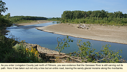
IntroductionThe region along the Genesee River from the Hamlet of Fillmore to the Village of Mt. Morris is an interesting one and involves three counties: Allegany, Wyoming, and Livingston. Only Livingston is in the Finger Lakes Region. (Just to make things complex, Allegany is in the Chautauqua-Allegheny Region and Wyoming is in the Greater Niagara Region.)
This is farm county with small hamlets and villages dotting the countryside here and there. The main ones along the river are Fillmore, Portageville, and Mt. Morris, with Castile off to the west.
The scenery is beautiful, but don't expect fancy restaurants, theatres, and shopping malls. The Genesee provides the best entertainment 365 days a year. BoatingNote: All of the following launch sites are hand launch only. Motorboating is not possible on this section of the Genesee.
East Main Street Bridge-Fillmore (Allegany County) The launch is approximately .5 mi./.8 km. east of the intersection of State Route 19A and Main Street in the Hamlet of Fillmore on the southwest side of the bridge. Large parking area. Short path to the water. No amenities.
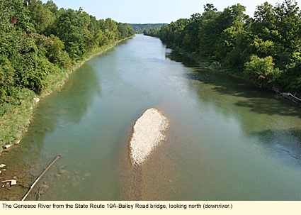
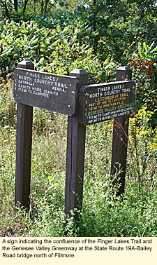
State Route 19A-Bailey Road Bridge (South of Portageville) This bridge runs between State Route 19A in Wyoming County and the intersection of Bailey and Bolton roads in Livingston County. The bridge is also the confluence of several hiking trails belonging to the Finger Lakes-North County Trail and the Genesee Valley Greenway.
To access the launch site, drive .4 mi./.6 km. south of the bridge on State Route 19A. Turn east onto West River Road. (This dirt road runs parallel to 19A and only goes to the launch site. ) Follow the road north .4 mi./.6 km. It will take you under the bridge. Steep slope to the water. No amenities.
(Note: The paddle between this bridge and the Fillmore bridge is a popular one and very scenic. It is just about 10 mi./16 km.)
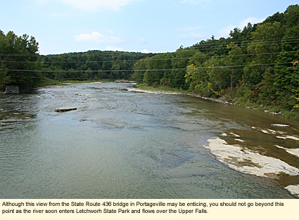
State Route 436 Bridge-Portageville Parking area is on the southeast corner of the bridge-river intersection. No amenities. This is the last launch site before entering the Genesee River Gorge and Letchworth State Park. Do not go north of this launch site, waterfall ahead.
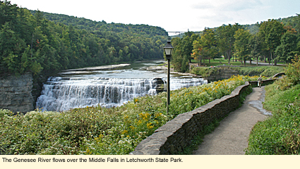
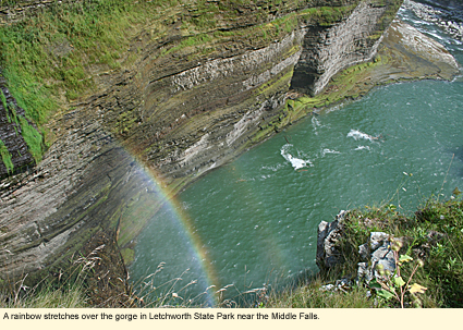
The park encompasses 14,350 acres and is roughly 15 mi./24 km. long. Because of the gorge, it is often called the Grand Canyon of the East. A busy park with many amenities, it has the feel of a national park, one in which you could spend many days exploring. The Genesee River is the principal focal point of the park and provides three main waterfalls as well as boating and whitewater rafting opportunities.
At the northern end of the gorge, the river is dammed by the Mt. Morris Dam. North of this dam is another dam that, at one time, produced electricity for Rochester Gas and Electric. The dam still exists but no longer produces electricity. The water spilling over this dam runs under the State Route 36 bridge in the Village of Mt. Morris. Whitewater ClassificationOutside the park, the river has no whitewater classification. Inside the park, it is listed as Class I-II. Canoers and kayakers must register with the park. Participants must be experienced whitewater paddlers and good swimmers. Those under 18 years of age must be accompanied by an adult. See also: http://www.letchworthpark.com/generalinfo.htm.
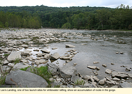
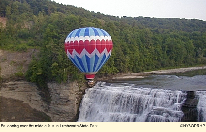
Water LevelSwimmingLetchworth State Park offers two swimming pools for supervised swimming. Swimming in the river in the park is prohibited. Few people live directly on the river, so little regular swimming takes place by the locals, however, it is not prohibited and would be fun anywhere from Fillmore to Portageville. Whitewater RaftingP.O. Box 391 LeRoy, NY 14482 888-270-2410 Ballooning6645 Denton Corner Rd. Castile, NY 14427 585-493-3340
WildlifeIntimate rivers tend to be more likely to provide wildlife watching opportunities than wide rivers. This is the case with the Genesee. It is wide and generally free of debris, so it is unlikely that you will see beavers, muskrats, or many herons on the river. However, you should be able to bird with binoculars for warblers, flycatchers, gnatcatchers, and woodland species. Turkey vultures may be seen flying overhead especially in Letchworth State Park where you will see large groups called "kettles," as the birds nest in the gorge. BikingThere is no biking trail directly along the river, however, State Route 19A ,on the west side of the river, is a lovely route with a paved shoulder. Another interesting state road is Route 36, which comes up from Steuben County. You can bike from Stoney Brook State Park to the north entrance of Letchworth without ever HikingThere are numerous hiking opportunities outside Letchworth State Park. They include the Genesee Valley Greenway mentioned above, and the Finger Lakes Trail section of the North Country Trail. Inside Letchworth there is more than 65 mi./105 km. of trail, including part of the Finger Lakes Trail. (See map of park.) You may also want to purchase the "Letchworth State Park Trail Guide," which is available at the Visitor's Center and the Museum. Parks, Forests and Wildlife Management AreasRattlesnake Hill Wildlife Management Area Note: There are also a variety of accommodations in Letchworth State Park.
Created 30 September 2009
|
|
 getting off Route 36. You can also bike on any of the roads in Letchworth State Park. All roads are paved but have no shoulders. You can also pick up the
 |
|