The Genesee River in the Finger Lakes
PART 1-LOCATION AND PHYSICAL FEATURES
Part 2-Fillmore (Allegany County) to the Mt. Morris Dams (Livingston County)
Part 3-Mt. Morris (Livingston County) to the State Route 253 Bridge in Scottsville (Monroe County)
Part 4-Black Creek to Genesee Valley Park
Part 5-Genesee Valley Park to Lake Ontario
Location
The Genesee River starts rather humbly as a spring on a farm in northern Pennsylvania. It then flows north into New York along State Route 19 in Allegany County. It continues through Allegany County, which is not in the Finger Lakes Region, and north into Livingston County. On passing into Livingston County, the river enters into the Finger Lakes. Even at this stage, the Genesee River is a body of water with considerable force and beauty.
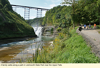
The river continues along State Route 19A to Portageville, where it flows through the Genesee River Gorge in Letchworth State Park. Here one can clearly see how the river has scowered the land, carving a deep and scenic gorge with three main waterfalls. The river continues through the gorge to Mt. Morris where it is dammed twice.
It then travels through the wide, flat Genesee River Valley in northern Livingston County and some of the best agricultural land in the state. Flowing ever northward, the river passes into Monroe County.
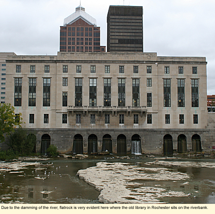
Nearing Rochester, it flows through residential and business areas, along highways, golf courses, and even the regional airport. The river is intersected by the Erie Canal, passes through a park designed by Frederick Law Olmsted, and then flows into downtown Rochester where it is again dammed.
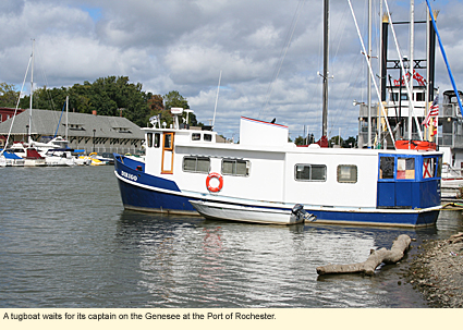
As the river nears its end at the Lake Ontario shore, it flows over three more waterfalls. It then flows through a neighborhood of Rochester called Charlotte (pronounced sharLOT) and past the Charlotte-Genesee Lighthouse, which overlooks the Port of Rochester. Here are boat docking facilities, restaurants, and Ontario Beach Park with its famous carousel. Next to the park is a long pier that guides the river into the lake in a rather final but unceremonious fashion.
Physical Features
The Genesee River is 157 mi./253 km. long from end to end and is the only river to bisect the state. The geology of the river is discussed in detail in Roadside Geology of New York (see below). Here is the lay version.
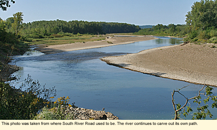
By the time the river enters the Finger Lakes in Livingston County, the river is strong and has carved out a deep path through moraine (sandy soil and small stones) and carried much of it downriver. In this area, some of the banks are 20 ft./6 m. or more high with the river still actively working away at the banks, bringing down trees and, in the case of South River Road, taking out so much bank that it took the road with it.
The moraine that's washed downriver, collects in the river as small islands until they are washed further downriver. In many places the river has scowerd the moraine down to "flat rock." This is a local term for a flat layer of rock (often ancient compressed sediment) that can cover the entire river bed.
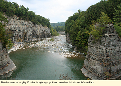
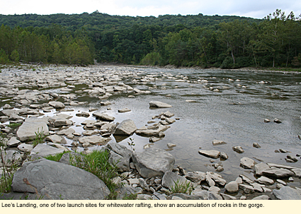
When the river enters the Genesee River Gorge in Letchworth State Park, the gorge is even deeper and the sides of the gorge are thin layers of shale similar to what is seen in Watkins Glen, Taughannock Falls, and other state parks in the Finger Lakes region. Over time, sandstone boulders have accumulated in the riverbed and, when the water level is high enough, these help create conditions good for whitewater rafting. The boulders are particularly in evidence near Lee's Landing.
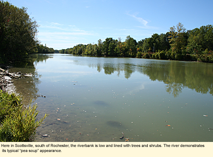
North of the park and Mt. Morris is the Genesee River Valley where the river runs much nearer to the level of the land. The soil is sandy, drains will, and is good for growing crops. (Some have said that is this some of the best cropland in the country.) The river bank in this section is a bit muddy and covered with trees, bushes, vines, and other plants. The current is not particularly fast, and the occasional tree trunk can be found in the water, but there are no serious obstructions.
When the river flows north of the City of Rochester, it enters another gorge, not one as deep as in Letchworth, but a gorge nonetheless, with three waterfalls.
At the mouth of the Genesee, the river has been widened and reworked to accommodate a port, so it no longer resembles a "wild" river. Still, the river is free flowing and rather mild.
The water when it enters the Finger Lakes region is fairly clear, but by the time it has reached Letchworth, it has taken on its typical greenish cast. This remains the case for the rest of the length of the river, and by the time the river runs through the Port of Rochester, it can have a rather "pea soup" appearance.
A Note About Regions
The Genesee River is the dividing line between the Finger Lakes Region and two other regions: the Greater Niagara and the Chautauqua-Allegheny. If you plan to visit the Genesee River and are coming from the west or southwest, you may want to consider contacting these two regions for tourist information.
Created 30 September 2009
|