- Site Indexes
- Search by Keyword
- Search by Topic
- Search by Place
- Things to Do
- Entertainment
- Recreation
- History
- Basics
- Accommodations
- Have Some Fun
- Fun Stuff
- Kid Stuff
- Food and Recipes
- Send a Postcard
- Wallpaper
- Our Site
- Site Info
- Contact Us
- Home
xxxx
xxx

x
Home > Basics > RiversSusquehanna River in the Finger Lakes
The name Susquehanna is said to mean "muddy waters." It can be that at times, but, in general, the waters of the Susquehanna are a deep green. This only contributes to the character of the river that at times can be either haunting, romantic, or exciting.
The entire Susquehanna River is 444 mi./714.4 km. long and runs through New York, Pennsylvania, and Maryland where it enters the Chesapeake Bay at Havre de Grace before making its way into the Atlantic Ocean. It is the largest river in the United States lying entirely within this country. Some geologists believe it may be one of the oldest river systems in the world. LOCATIONThe Susquehanna begins its life far from the Finger Lakes as the outlet to Otsego Lake in Otsego County, New York. It winds its way southeast through a number of counties, entering the Finger Lakes at Apalachin in the eastern part of Tioga County. It flows west through the southern part of Tioga County before turning south into Pennsylvania.
HISTORYThe Susquehanna has always been an important river. Hundreds of years ago, it was used by American Indians as a transportation corridor, moving people and goods from place to place. Once the Indians were driven from the area, American and European settlers used the Susquehanna to again move people and goods into and out of the region. Towns sprang up along the Susquehanna and mills ran in the creeks that fed the river.
Unfortunately, there was a price to pay for this prosperity. Toxic chemicals, agricultural runoff in the form of manure, pesticides, and herbicides, as well as human waste all find their way into the river. That has prompted the New York State Department of Health (DoH) to issue the following advisory:
WARNING: Walleye in the Susquehanna River are contaminated with mercury. The DoH recommends that people eat no more than one meal per month of walleye over 22 in./55.8 cm. Women of childbearing age and children under the age of 15 should eat none. DoH Advisory
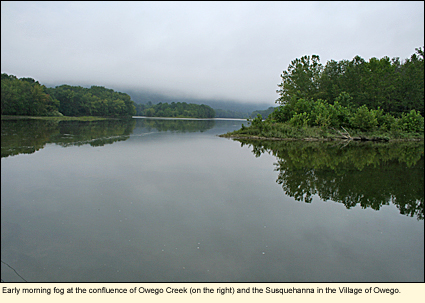
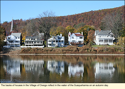
Physical FeaturesIn the one county in which the Susquehanna runs in the Finger Lakes, the river is broad, flat, free flowing, winding, and ever changing in view. Some houses and small towns boarder the river, but much of ithe area is agricultural or open land. There are a number of islands in the river, but only one--Hiawatha Island--is open to the public. The entire section through Tioga County is about 22 mi./35.4 km. long.
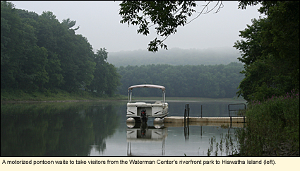
The current of the river varies, of course, with the amount of water in the river, however, it sometimes seems that the closer the river gets to the Pennsylvania state line, the faster the river flows, as if it's in a hurry to be heading south. Boaters should be aware of this current and take it into consideration planning a trip. HIAWATHA ISLANDOne of the more interesting physical features of the river is Hiawatha Island, owned by the Fred L. Waterman Conservation Center in Apalachin, New York. Today, the island is open to the public and is located directly across the water from a riverfront park owned by the Center near 126 East Marshland Road, Owego. Each July the Center holds a "Walk Through Time" weekend where visitors are shuttled across from the park to the island to listen to a story of the island's history as told by Emma M. Sedore, a local resident and author of Hiawatha Island: Jewel in the Susquehanna. With your own boat you can visit the island and explore its trails and view the surrounding area from the observation tower. (See a video about the island.)
Owego River Walk ProjectBoatingHard-surface ramps are supplied at some boat launches with the assumption that some boaters will be launching motorboats, however, the majority of boat traffic is kayak and canoe.
It should also be pointed out that Binghamton University's Crew Club practices on this section of the river and that the Hiawatha Island Boat Club (a sculling club) meets in the same area. Both use the Les Wagner Rowing Center as home base.
Here are the official and non-official launch sites. (Notes: 1) This should not be considered a definitive list. 2) D=Officially designated launch site. 3) Sites are listed in order of river flow from upriver to downriver.)
Apalachin (D) Valley View Drive Bridge between State Routes 17C and 434. Concrete ramp. Parking for 20 vehicles and trailers. Owego (D) Near 126 East Marshland Road. Hard surface ramp. Parking for 10 vehicles and trailers. (This site is next to the Waterman Center's riverfront park. A hand launch is available. Parking is limited.) Owego (D) Hickories Park, Hickories Park Road. Hard surface ramp. Parking for 6 vehicles and trailers. More parking nearby. Owego (D) Canal Street. (This is the confluence of the Susquehanna and Owego Creek.) Hand launch only. Parking for 1-2 vehicles. Hamlet of Barton Old Barton Road near the intersection of Oak Hill Road in town park next to the post office. Launch is a short trail to the river among some trees. Parking for 1-2 cars. Park has a picnic pavilion and a basketball court. Hamlet of Barton (D) Old Barton Road about 1.7mi./2.7 km. west of post office. Hand launch. (Launch is a drop of about 2 ft./60 cm. from the bank to the water in among some trees.) Parking for 10 cars. Nichols (D) On East River Road 1 mi./1.6 km. east of the village. Concrete ramp. Parking for 12 vehicles and trailers. Nichols (D) On West River Road about 4 mi./6.4 km. west of the village. Concrete ramp. Parking for 8 vehicles and trailers. This is the last launch site before the Susquehanna crosses the state line. Litchfield, Pennsylvania (D) .4 mi./.6 km. south of state line on right. (The road here is called SR 1043.) Gravel drive, parking, and ramp. Parking for about 10 vehicles and trailers. This launch site is only several miles above the confluence of the Chemung and the Susquehanna.
Whitewater ClassificationThe Susquehanna has no whitewater designation in Tioga County. Water LevelWildlife
BikingState Route 17C, which begins near the Hudson River, runs along the Susquehanna, and continues along the Southern Tier of New York, is a state bikeway. Through the Finger Lakes, this route is relatively flat with good roads and paved shoulders. It is a pleasant ride spring through autumn. Some on-line maps of the route are here. SwimmingThe Susquehanna River normally has more silt in the water than most swimmers care to tolerate. In addition, because of the current and depth of the river, swimming by unsupervised children is not recommended. Swim at your own risk. Parks, Forests, and Wildlife Management Areas
|
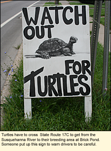 The river provides many opportunities for viewing wildlife, everything from raccoons and mink to ospreys and eagles.
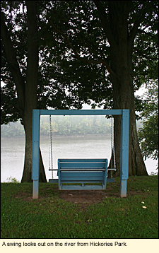
|
|