The Chemung River in the Finger Lakes
Location
The Chemung River begins at the confluence of the Cohocton and Tioga rivers just south of the village of Painted Post in the Town of Erwin in Steuben County. The river travels southeast through the City of Corning, then southeast into Chemung County and through the City of Elmira, then east to the Tioga County line where it heads south into Pennsylvania and its rendezvous with the Susquehanna.
Physical Features
The Chemung is a large, broad river, with a rocky bottom. It travels through a variety of habitats and its shoreline changes accordingly. In rural areas the banks are covered with thick vegetation, making the river feel more closed in, more private. In the Corning, the river is very broad and the low shore is mowed grass followed by mowed dikes. In Elmira, the riverbanks are again grassy, and the river is confined by high walls. The river has a number of islands, all privately owned and off limits to visitors, but they can be explored visually. The river is crossed by many bridges that add to its scenic beauty.
Historic Bridges
Bridge Street Bridge
Centerway Bridge
River Festivals
River Float
When: Last Friday in May
Sponsored by: Southern Tier Central Planning
Contact: 607-962-5092
Paddle on the river from one location to another.
River Fest
When: first Saturday in June
Sponsored by: Near Westside Neighborhood Assoc., Inc., Elmira
Contact: 607-733-4924
Paddle on the river plus music, demonstrations, and other events at the Grove Street launch site in Elmira.
Boating
Over the past few years, a concerted effort has been made to clean up and revitalize the river. Junk and trash have been removed, and the river contains very little fallen vegetation. In general, when the water is high enough, the river is boatable its entire length in the Finger Lakes region.
The river tends to be muddy after a rain, and the current is such that most paddlers head downriver. only.
Here are the official and non-official launch sites.
(Notes: 1) This should not be considered a definitive list. 2) D=Officially designated launch site. 3) Sites are listed in order of river flow from upriver to downriver.)
Kinsella Park (D)
(This is the last site on the Cohocton River and provides access to the beginning of the Chemung.)
On Canada Road in the Town of Erwin. This is a town park with ball fields, picnic tables, a pavilion, and toilets. Immediately after this launch site, the river is channeled and then quickly meets the Tioga River to form the Chemung.
Hillvue Park-Village of Riverside
Once you've paddled through the confluence of the Tioga and Cohocton rivers, you will be on the Chemung. The first place to enter or exit the water is at Hillvue Park on Hillvue Avenue in the Village of Riverside. There is a long dike/berm along the riverbank. Most of the park is on the street side of a dike, making it difficult to see that it's really a park, despite the fact that it has a playground, toilets, picnic tables, and walking, jogging, and biking paths. If you want to launch from this spot, park on the street and carry your boat over the dike. The area is mowed grass. Hand launch only.
Conhocton Street-City of Corning (D)
42°08.722’N 77°02.361’W
Follow Conhocton Street east all the way to the end. Continue over the dike to the launch site at the river. Hand launch only.
River Road-Village of South Corning (D)
42°06.952'N 76°00.317'W
On County Route 44/River Road just west of the Steuben/Chemung county line on the north side of the road. Small parking lot. Concrete steps to the water.
Bottcher's Landing-Town of Big Flats (D)
42°07.469'N 76°57.091'W
At the County Route 10 bridge over the Chemung just east of the Steuben/Chemung county line. The road runs north/south at this point and the entrance to the launch area is on the east side of the road on the north shore. Large parking area. Paved ramp.
Minier's Field-Town of Big Flats (D)
42°07.292'N 76°55.977'W
The is a town park with ball fields and picnic tables.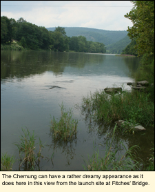 Located on State Route 352 just south of Carpenter Road on the west side of the road. Once you've turned into the park, take the road along the south side of the park all the way back behind the ball fields. Small parking area. Hand launch only. Located on State Route 352 just south of Carpenter Road on the west side of the road. Once you've turned into the park, take the road along the south side of the park all the way back behind the ball fields. Small parking area. Hand launch only.
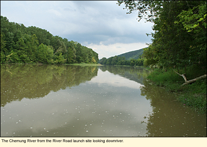
Fitches' Bridge-Town of Big Flats (D)
42°04.949'N 76°51.939'W
Near the intersection of State Route 352 (Church St.) and State Route 225 (Hendy Creek Rd.) on the southeast side of 225. Large parking area. Hand launch only.
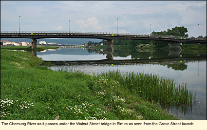
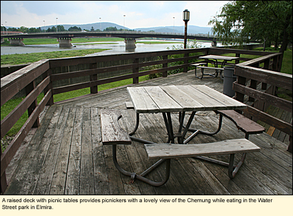
Grove Street-City of Elmira (D)
42°04.972'N 76°49.019'W
At the eastern end of Grove Street off Water Street in the heart of the city. You must be careful as you approach the paved entrance to this area. Once you've passed the last house, the drive goes up over a dike. The dike is very steep and seeing someone coming from the opposite direction is impossible. You must be sure to stay to the right. Assuming you survive that unscathed, continue to the parking area ahead. Paved ramp.
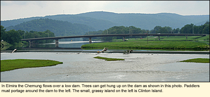
(Note:) Just downriver from the Grove Street launch is a low dam that stretches across much of the river. Unless the water level is very high, you will not be able to paddle over the dam. Paddlers should take out on the south shore just before the dam and portage around the dam. Motorboats will need to exit at Grove Street and drive down to the next launch site.)
Dunn Field-City of Elmira (D)
42°04.875'N 76°46.776'W
At the end of Luce Street off Maple Avenue near Dunn Field Municipal Stadium. Continue over the dike. Small parking area. Paved ramp.
 Toll Bridge Park-Village of Wellsburg (D) Toll Bridge Park-Village of Wellsburg (D)
42°01.053'N 76°43.390'W
Toll Bridge Park is located off County Route 8 just east of the hamlet of Wellsburg near the intersection of State Route 427. This is a town park with a pavilion and picnic tables. Parking lot. Hand launch only.
State Route 427-State Line
Near the New York-Pennsylvania state line in the Town of Chemung, State Route 427 passes over the Chemung and under State Route 17/86 at Exit 59. (Note: This road that passes over the Chemung and under 17/86 is sometimes listed as County Route 3.) There is a boat launch area under 427 where it crosses over the river. The drive to the site is a bit long and rutted due to constant use. Parking for 3-4 vehicles. Hand launch only.
The Chemung then dips into Pennsylvania and then back into New York where there is one last boat launch area:
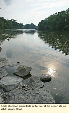
White Wagon Road-Town of Chemung
Near the Pennsylvania state line the Chemung loops before it heads south into Pennsylvania. White Wagon Road passes under State Route 17/86 at Exit 59A. In New York, White Wagon Road is a short road that doesn't go through. The boat launch is midway along this road on the north side. The site has a large gravel parking lot with a gravel ramp.
Whitewater Classification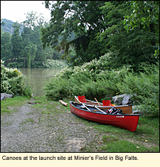
The Chemung is a Class I river.
Water Level
Streamflow Conditions
Boat Rentals
Endless Mountain Outfitters
Clubs
Ahwaga Canoe & Kayak Club
Chemung Valley Virtual Canoe and Kayak Club
Swimming
The water of the Chemung is never completely clear as it is with the Cohocton. But swimmers who don't mind the color of the water will find that, at certain times, its depth is ideal for swimming. There are no places along the river where there is supervised swimming, so swimmers will have to pick their spots carefully. The boat launch on River Road south of Corning is one place that appears to be popular with swimmers.
Wildlife
The variety of wildlife along the river is extensive and will change depending on the habitat. The river contains a number of species of fish and is frequented by various reptiles and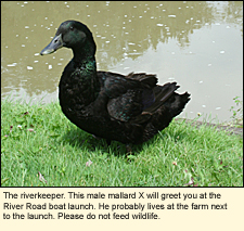 amphibians. Otters, mink, racons, foxes, coyotes, and deer, as well as the occasional bear may be seen. The river also attracts a wide variety of birds, including swallows, herons, geese, ducks, eagles, ospreys, and birds that like the brushy habitat along riverbanks like catbirds, towhees, common yellowthroats, and wrens. There is said to be a large colony of ring-billed gulls breeding on the gravel island in Elmira. Ring-billed gulls do patrol most of the waters in the area. amphibians. Otters, mink, racons, foxes, coyotes, and deer, as well as the occasional bear may be seen. The river also attracts a wide variety of birds, including swallows, herons, geese, ducks, eagles, ospreys, and birds that like the brushy habitat along riverbanks like catbirds, towhees, common yellowthroats, and wrens. There is said to be a large colony of ring-billed gulls breeding on the gravel island in Elmira. Ring-billed gulls do patrol most of the waters in the area.
Information on birding along the Chemung River
Biking
The entire route of the river is along or near State Bike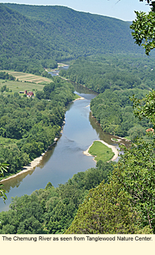 Route 17. The route is not very hilly, stays on paved roads for the entire trip, and can be quite scenic. If you like cross-state or cross-country trips, this is a nice ride. Route 17. The route is not very hilly, stays on paved roads for the entire trip, and can be quite scenic. If you like cross-state or cross-country trips, this is a nice ride.
A nice biking loop is made by the Riverfront Levee Trail and the River's Edge Trail on the north side of the river in the City of Elmira. For directions and photos of this loop, click here.
Geocaching
Geocaching is very popular in the Finger Lakes. If you enjoy geocaching, check for caches along the Chemung River at Geocaching.
Parks, Forests and Wildlife Management Areas
West Hill State Forest
Two Rivers State Park
Nearby Places of Interest (a partial list)
Chemung Valley History Museum
Corning Museum of Glass
John W. Jones Museum
Mark Twain's Study
National Soaring Museum
Tanglewood Nature Center
Woodlawn Cemetery
Accommodations
HOTELS & MOTELS
Hotels and motels can be found in the cites of Corning and Elmira as well as in the village of Painted Post.
Updated 2 April 2021
|