- Site Indexes
- Search by Keyword
- Search by Topic
- Search by Place
- Things to Do
- Entertainment
- Recreation
- History
- Basics
- Accommodations
- Have Some Fun
- Fun Stuff
- Kid Stuff
- Food and Recipes
- Send a Postcard
- Wallpaper
- Our Site
- Site Info
- Contact Us
- Home
xxxx
xxx

x
Home > Recreation > State ParksGreen Lakes State Park7900 Green Lakes Rd. Fayetteville, NY 13066 Park Office: 315-637-6111 Golf Course: 315-637-4653 Services: A,B,D,E,F,G,I,J,K,L,M,O,P,Q,R,U,V,Z,BB,CC
Named in 2004 as one of the Top 100 Campgrounds in the nation.
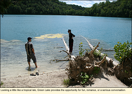
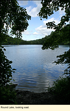
GEOLOGICAL HISTORYLocated in the Town of Manlius east of the City of Syracuse, Green Lakes State Park's outstanding features are its two glacial lakes--Green and Round--surrounded by upland forest. Green Lake has a water depth of 195 ft./59.4 m. while Round is 180 ft. /54.8 m. Considered very deep, the lakes are thought to have originally been catch basins created by ancient waterfalls. Both Green and Round lakes are meromictic, having no autumn and spring mixing of surface and bottom waters. Because of this, the water below about 70 ft./21.3 m. is a "dead zone" with little oxygen. Organic
Aquatic bacteria and other organic material in the water reflects sunlight, making the water look green. The lakes look their greenest when the water is the warmest, usually during July and August.
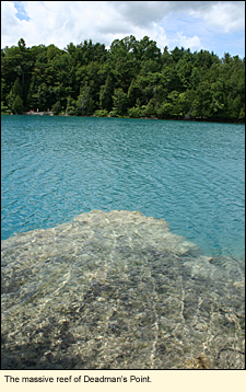
In addition, both lakes have a high level of calcium carbonate precipitated by these small aquatic bacteria. Over time, this calcium carbonate settles out in shallow areas like Deadman's Point, becoming massive reefs that can be seen just below the surface of the water. Various species of photosynthetic aquatic bacteria in the lakes can, at certain times and weather conditions, turn the water at a certain level interesting colors (rosy pink or purple, for example) and cause the water to emit a sulfurous odor.
Lakes of this type are very rare and almost non-existant in the United States. Because of this, both Green and Round lakes have been heavily studied and NOVA scienceNOW aired a program on the lakes. (Read a transcript of the November 21, 2006 episode.)
RECREATIONAL OPPORTUNITIESThe park also has an old-growth forest, considered one of the largest in the northeastern United States. Through some of the forested land, visitors will find over 20 mi./32.1 km. of trails for walking, hiking, and cross-country skiing with foot trails around both lakes. Bicycling is permitted on some of the trails, especially those that are paved. The park roads are also excellent for biking. Pick up a trail brochure at the entrance to the park.
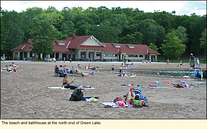
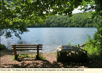
Round Lake has been designated a National Natural Landmark by the U.S. Department of the Interior. Because of this designation, no recreational activity is allowed in or on the lake. The northern end of Green Lake has been converted into a swimming area with a sandy beach, sunbathing area, bathhouse, boathouse that rents rowboats and paddleboats, and concession stand. Swimming is allowed only in the designated area. Only rental boats may be used on the lake.
The park also offers many opportunities for nature photography and wildlife watching. Check out the photos of photographers Bob Gates and Matthew Conheady.
In the southeast corner of the park, on a rise overlooking the lakes, is an 18-hole, par 71 golf course, one of the first designed by Robert Trent Jones. Set on a rolling hillside, the terrain challenges even the best golfers. The clubhouse, restaurant, and sports bar look out over the course and the lakes.
Green Lakes is the only state park in the Finger Lakes region that has a disc golf course. This is a 9-hole course with short, treed holes. The shortness of the holes makes it good for amateurs, especially children and families. More info
In winter, in addition to the park's 10 mi./16 km. of trails for cross-country skiing, visitors may snowshoe on the golf course. There is no winter camping. Pets must be leashed.
1,756 acres, 137 campsites (42 electric), 7 cabins, nature center
Trail map and camping area map (pdf)
Within Easy Driving DistanceNote: An entrance to the Old Erie Canal State Historic Park is directly across the road from the entrance to Green Lakes State Park. You can park in the Green Lakes parking lot and walk across the road. The trail at this point is either paved or cinders. A main entrance to the Canal Park is about 1 mi./1.6 km. to the west at the junction of State Rts. 257 & 290. There is parking there as well and a small box next to the trail that sometimes has maps. There is also a standing billboard there with a map of the trail. Key to ServicesA-Beach B-Biking
D-Boat Rentals E-Cabins F-Camper Recreation G-Campsites H-Dockage I-Dumping Station J-Empire Passport Accepted K-Fishing L-Food M-Hiking N-Marina O-Nature Trail P-Pavilions Q-Picnic Tables R-Playground S-Playing Fields T-Powerboats U-Recreation Programs V-Showers W-Sledding X-Snowmobiling Y-Snowshoeing Z-Tent/Trailer Sites AA-Vacation Rentals BB-X-Country Skiing CC-Scenic Views DD-All above
Updated 6 January 2013
|
 material tends not to decay but falls to the bottom of the lakes and creates a thick layer of sediment. Such lakes have few fish but a high potential for evidence of ancient plant and animal life.
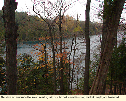
 C-Boat Launch Sites
|
|