The Seneca River in the Finger Lakes
Location
Today, the Seneca River begins as the outlet to Seneca Lake in Seneca County where it flows east to the north end of Cayuga Lake in Cayuga County, then east as the Erie Canal through Cross Lake in Onondaga County where it winds and loops until it meets with the Oneida River, which flows east to west, at the Hamlet of Three Rivers, where the two rivers become the Oswego River. The Oswego flows north and empties into Lake Ontario.
History and Physical Features
With the help of the David Rumsey Historical Map Collection, one can see how Americans have changed the Seneca River over the centuries. On the early maps of New York State, the outlet of Seneca Lake was called the Scayace River. This was later changed to the Scawpace. Whatever its name, it was considered separate from the Seneca River, which flowed from the northern end of Cayuga Lake. Over time, the Seneca River, including the part formerly called the Scawpace, was dammed, channelized, and locked until it is hard to determine today where parts of it are or were.
What's also interesting are the things that have not changed. The Seneca River has always been known as the Seneca, it has always passed through Cross Lake, and Three Rivers has always been Three Rivers, even as far back as 1776.
Today, there are a number of populated areas along the river and some towns like Baldwinsville and Seneca Falls are trying to preserve for public use what little is left of their riverfront. But much of the river is still sparsely populated and is lined with trees or wetlands. The channelizing of the river has created a number of islands around which one may boat, and Howland Island is now a state wildlife management area that is closed to vehicular traffic but has nature trails that can be explored. Because the river is now part of the Erie Canal system, a certain depth is maintained, making the river suitable for paddling and motorboating. It is free flowing its entire length with little vegetation in the river.
WARNING: According to the New York State Department of Health (DoH), many of the fish in the Seneca River downstream of Lock 24 at Baldwinsville are contaminated with mercury, dioxin, and PCBs. The DoH recommends that people eat no walleye, no largemouth or smallmouth bass over 15". It also recommends that people eat no more than one meal per month of all other species. Women of childbearing age and children under the age of 15 should eat none. DoH Advisory
Boating
The Seneca River is boatable for most of its length. Here are its launch sites in order of flow.
Seneca Lake State Park-Geneva
The park has two marinas. The one with electric is at the entrance to the Cayuga-Seneca Canal, the one without is on a small channel just a matter of feet from the Canal. Both have concrete launch ramps. The park has many amenities. At certain times of the
year, the park charges an entrance fee. Brochure.
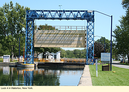
Oak Island (Oak Street off Main)-Waterloo
Oak Island is a village park with toilets, a picnic pavilion, and flower gardens just across the canal from Lock 4. There are several concrete ramps and docks, as well as a large parking lot. Brochure.
Oak Island Web Cams
Luce's Park-Waterloo
This is a nice but very small park that you might miss. It is located on the north side of East River Road just east of the water treatment plant. In fact, you actually have to pull into the parking lot on the east side of the water treatment plant building and park near a sign that says "Luce's Park." There is a single picnic table under a tree but no other amenities. Hand launch only.
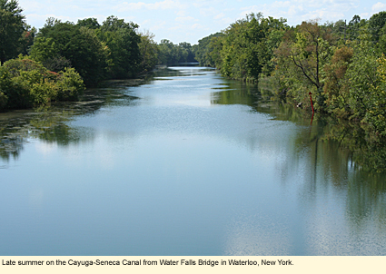
Water Falls Bridge-Waterloo
This bridge runs between East River Road and the intersection of routes 5 & 20 and 414. (5 & 20 is a single road, at least in Waterloo.) Despite its name, there are no falls here. Cross over the bridge to the north side of the canal and pull into a bank parking lot. Along the edge of the parking lot near the canal is a decorative retaining wall. At the west end of the wall is a set of concrete steps to the canal. At the east end of the wall is a grassy slope. If you use the steps, be sure to test them first as one step was loose recently. No amenities. Hand launch only.
Continue on to Seneca Falls, the birthplace of the Women's Rights Movement and home of the Women's Rights National Historical Park. Pass under Veterans' Memorial Bridge and the Bridge Street Bridge. Along the south shore of the canal is the Frank J. Ludovico Sculpture Trail. This is a 1.75 mi./2.8 km. trail that incorporates art with a lovely walk along the canal.
Seneca Falls Recreation Center-Seneca Falls
Located at 35 Water Street, this is a hand launch site. Unfortunately, it is a bit redundant as just a few hundred feet further downriver you come to...
Seneca Harbor-Seneca Falls
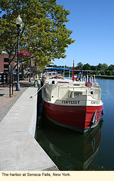 Free docking for 48 hours. Free electric and water hookups. Wooden dock from which to hand launch but no ramp. Large but busy parking lot. Walking access to much of the village. This is also home port for Liberty Boat Tours, which not only offers boat tours along the canal but rents canoes, kayaks, pontoon boats, and bicycles. Free docking for 48 hours. Free electric and water hookups. Wooden dock from which to hand launch but no ramp. Large but busy parking lot. Walking access to much of the village. This is also home port for Liberty Boat Tours, which not only offers boat tours along the canal but rents canoes, kayaks, pontoon boats, and bicycles.
When Locks 2 and 3 were installed, this caused a damming effect, which created a widewater locally called Van Cleef Lake, though it is not really a lake.
Locks 2 and 3
Wooden dock for hand launching. Small parking lot. No amenities.
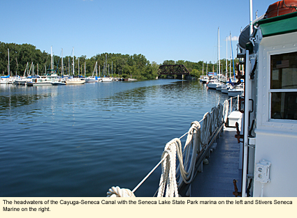
The Cayuga-Seneca Canal now heads east across the northern tip of Cayuga Lake, providing access to the lake. Montezuma National Wildlife Refuge will be to the north. Watch for eagles and ospreys here. The canal then turns north to Lock 1.
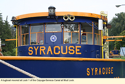
Lock 1-Mud Lock
The lock and a state-operated launch site join here. Concrete ramp, picnic tables, toilets, and large parking lot. This site can be very windy and much colder than the surrounding area. The water where the canal passes through the lake is often very choppy. Brochure.
Just north of Lock 1 the canal passes under the Menard Memorial Bridge on routes 5 & 20, This bridge commemorates Father René Menard's visit to the region in 1656 to convert Indians to Roman Catholic. Continuing on routes 5 & 20, just west of the bridge (and almost opposite the entrance to the wildlife refuge) is a one-lane, dirt road to the south that will lead you to a state-operated launch.
Routes 5 & 20-Montezuma National Wildlife Refuge
Concrete ramp, portable toilet, large parking lot. No picnic table. This launch is still on the Cayuga-Seneca Canal, which runs on the outer edge of the refuge. There is no way to boat through the refuge. Brochure.
Continuing north along the canal, a small portion of what was once the Clyde River meets the Cayuga-Seneca Canal and then, within a matter of a few hundred feet, meets the Erie Canal. This is the end of the Cayuga-Seneca Canal. The Erie Canal continues east.
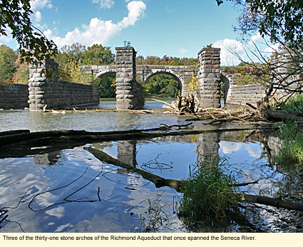
There have been several versions of the Erie Canal. The first version was built from 1817 to 1825 and was dubbed Clinton's Ditch by those who thought that Governor DeWitt Clinton's canal idea was crazy. This first canal crossed the current Erie Canal/Seneca River at Richmond's Aqueduct.
Named for Van R. Richmond, the engineer who designed it, the aqueduct was finished in 1852 and cost $216,510.63. Its purpose was to carry water and barges over the Seneca River. The aqueduct originally had 31 arches of which only 8 remain. When the last version of the Erie Canal closed in 1917, part of the aqueduct was torn down to give boats clear run of the river.
The aqueduct is a fine work of masonry, and what is still there is not only attractive but solid. You can dock your boat just north of the aqueduct among some trees on the east bank and explore the structure. The Town of Montezuma maintains a path to the aqueduct from Chapman Road.
Less than a mile north of the aqueduct you come to...
State Route 31 Bridge-Town of Tyre
Long, heavily rutted, dirt road on the north side of the road and the west side of the river. A Canal Corporation sign says "No Camping." No amenities. Hand launch only.
The river now heads north while the canal was cut through the land, creating several islands of which Hog, Howland, and Haiti are the best known.
There is a launch site on the opposite shore from Hog Island:
Railroad Road--Town of Savannah
Launch site is at the end of the road where it meets the river. Hand launch only. Parking for 3 vehicles. Brochure.
Howland Island is interesting enough to merit its own page.
Haiti Island is the only island inhabited by humans. Its one dead-end road must be accessed by a clattering wooden bridge. You might like to drive over it just for the fun of having done it. There are no public launch sites directly on the island, but there is one directly across from Haiti Island:
State Route 38 Bridge-Town of Mentz
This site is directly across the canal from Haiti Island and is another popular launch site. It is accessed by a one-lane dirt road just south of the bridge on the west side of the road. Concrete ramp, portable toilet, picnic tables. Keep in mind that the downriver end of Haiti Island, which you may wish to explore, isn't named Mosquito Point for no reason.
A cut creates another small island--Hickory Island--you may want to boat around, then it's on to the State Route 34 bridge. There is no public launch site here, however, there is a restaurant--Devaney's Riverside Grill--that has a dock for boaters using the restaurant.
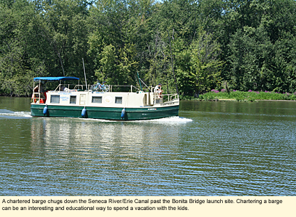
Bonta Bridge-Town of Brutus
Located on the aptly named Bonta Bridge Road, this is the last launch before Cross Lake. It has a small parking lot and a dirt path to the shore from the right of the lot. The site is designed for hand launch only and has no amenities. Some people have tried to create a road with some large vehicle from the left of the parking lot, but going this way is not recommended as the area can be rather swampy.
The river/canal now passes through Cross Lake. The canal cuts again through the land while the river dips through the Hamlet of Jack's Reef.
The Seneca River/Erie Canal winds around, heading mostly to the east. You'll go around a small island--Maloney Island--then under State Route 690 before coming to the Village of Baldwinsville. Walking Tour of Baldwinsville
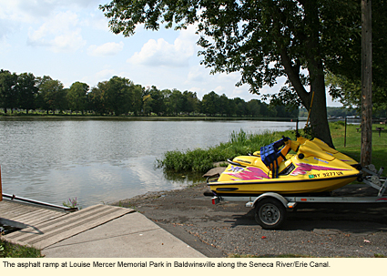
North Shore-Louise Mercer Memorial Park
This is a small village-operated park with an asphalt ramp and a dock next to a parking lot that can accommodate vehicles with trailers. The park also has a playground, gazebo, toilets, picnic area, pavilion, and a bit of sandy shore from which some boaters like to launch canoes or kayaks.
South Shore-Dock
Motorboats can moor here before going through Lock 24 and will find electric and water hook ups and picnic tables. There is a visitor's center on shore and the Southwest Trail (3,500 ft./1,068 m.) for strolling. An aluminum dock is available for hand launching.
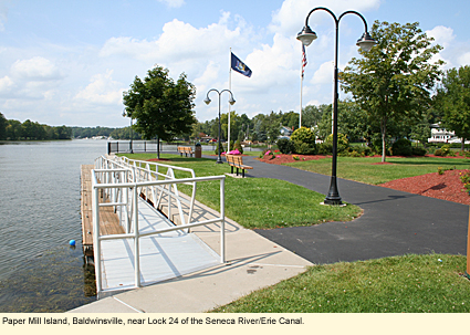
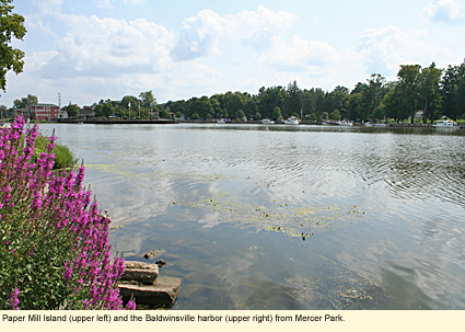
Paper Mill Island
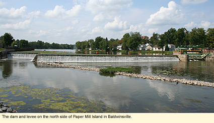
In the middle of the canal is Paper Mill Island where you'll find the Red Mill Inn, the Budweiser Amphitheater, a small park for relaxing, and a dock for mooring and launching boats. You can't boat around the island as there is a dam and levee on the north side.
Proceed through Lock 24.
Southwest Shore-Community Park
Located about .5 mi./.8 km. downriver of Lock 24 is Community Park, a small village park with a boat launch, picnic area, pavilion, ball fields, and toilets.
Continuing downriver a short distance, a cut creates Klein Island at the point where the Onondaga Lake Outlet meets the Seneca River. Klein Island is privately owned. If you turn into the outlet, you can boat directly into Onondaga Lake.
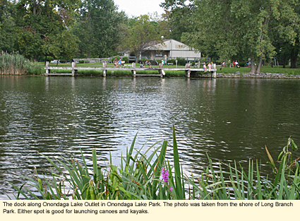
Long Branch Park-Onondaga Lake Outlet
When coming by car, the entrance to Long Branch Park is on Long Branch Park Road. When you enter the parking lot, take an immediate right and drive across the lot and across the grass to near the edge of the Outlet. No formal launch site. No amenities. Canoers and kayakers regularly use this site for accessing the river and the lake.
Onondaga Lake Park-Onondaga Lake Outlet
If you're coming by boat from the Seneca River, you will enter the Outlet and pass under the John Glenn Boulevard Bridge. Just before you reach the second bridge--the Long Branch Road Bridge--there will be a dock on the south shore in front of a modern gray building. You may moor here temporarily or put in or out a canoe or kayak. (This dock is directly opposite the Long Branch Park launch site mentioned above.) The modern gray building has public toilets.
Onondaga Lake Park-Onondaga Lake
Long Branch Park is connected to Onondaga Lake Park by a bike trail and by Long Branch Road. There are numerous spots along the lake shore and the river shore from which to launch a canoe or kayak. The park also has a marina for the docking and launching of motorboats.
(A note about Onondaga Lake Park: This is a fantastic park. It has miles of paved trails for biking, jogging, in-line skating, or just walking. There is a salt museum, a nature trail, a dog park, and many other amenities. Be sure to visit it if you are in the area. Free admission.)
Despite the fact that the Seneca River/Erie Canal go on for roughly 7 mi./11 km. beyond Klein Island, there are no more public launch sites. The next site is the last site on the Oneida River before the Oneida and Seneca converge at Three Rivers. In other words, you will have to pass by Three Rivers and go up the Oneida a short ways to put out.
Marinas
Cayuga-Seneca Canal
Cross Lake
Seneca River (Erie Canal)
Whitewater Classification
The Seneca River has no whitewater classification.
Water Level
Streamflow Conditions
Tours
Discovery Marine Services
Mercer Park
Baldwinsville, NY 13027
315-317-3694
Swimming
Although there are no supervised swimming areas along the Seneca River, the Seneca is a popular place to swim above Lock 24. Local residents swim off their docks. Here are some other places where people hang out.
Under the State Route 89 overpass at Lock 25 at Montezuma (This is actually the Erie Canal.)
Below the bridge to Howland Island (Erie Canal)
In Cross Lake
Do not swim below Lock 24 as the water is polluted by the water from Onondaga Lake, one of the most polluted lakes in the country. Swimming is prohibited in Onondaga Lake and in the outlet to the lake.
Wildlife
The river is long and passes through many habitats. Consequently, it is possible, if watching carefully on days when there is little boat traffic, to see a wide variety of animals, especially birds. The closer you get to Montezuma National Wildlife Refuge, the more birds you are likely to see, especially, ring-billed gulls, herons, ospreys, and bald eagles. If wildlife watching is one of your goals, bringing a pair of binoculars and a field guide to the birds of eastern North America would help you identify what you see. If you plan to visit Montezuma, there is a visitor's center near the entrance on routes 5 & 20 where a sign-in book is kept, listing what birds people have seen that day and where.
Festivals
On the second Friday and Saturday in July the Rotary Club of Baldwinsville hosts Seneca River Days at Mercer Park in Baldwinsville. There are numerous children's activities, a 5k run and "duck waddle" (race for children ages 6 through 12), and a duck (plastic) race down the river with prizes.
The Town of Montezuma in Cayuga County holds a festival in honor of one of the river's and Montezuma's most prominent wild animals. Called the Mosquito Fest, this three-day event occurs during the last weekend in August and features a cookout, a cake booth, amusement rides, a water ball tournament, and music. Come prepared to be welcomed by the guests of honor.
Biking
Although there is no bike trail right along the river, State Route 31, which is nearby, is designated as State Bike Route 5. It is mapped in Cycling the Erie Canal available through Parks & Trails New York. You can download maps of Route 5 directly from the Department of Transportation's Web site.
Parks, Forests and Wildlife Management Areas
Clark Reservation State Park
Green Lakes State Park
Old Erie Canal State Historic Park
State Park at the Fair
Nearby Places of Interest (a partial list)
Beaver Lake Nature Center
Erie Canal Museum
Montezuma Audubon Center
National Memorial Day Museum
Accommodations
BED AND BREAKFASTS ON THE RIVER
The Red Mill Inn
4 Syracuse St.
Baldwinsville, NY 13027
800-841-0411
Hubbell House on Van Cleef Lake
42 Cayuga St.
Seneca Falls, NY 13148
315-568-9690
CAMPING ON THE RIVER
Cayuga Marina and Campground
6721 River Rd.
Cayuga, NY 13034
315-0252-5754
Cross Lake Park Campgrounds
12946 Dugar Rd.
Cato, NY 13033
315-678-2143
Oak Orchard Marina & Campgrounds
State Route 89 at May's Point
P.O. Box 148
Seneca Falls, NY 13148
315-365-3000
Riverforest Campground, Marina & Restaurant
2526 Riverforest Rd.
Weedsport, NY 13166
800-772-2644
Sunset Park Campground
(on Cross Lake)
455 Sprague Rd.
Memphis, NY 13112
315-635-6450
HOTELS AND MOTELS
Check Geneva, Waterloo, Seneca Falls, Baldwinsville, and Liverpool for hotels and motels.
Updated 28 July 2011
|
