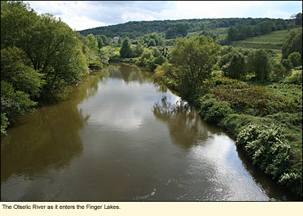
The Otselic River in the Finger Lakes
Location
The Otselic River begins in Madison County, flows into Chenango County, then into Cortland County, and finally into Broome County where it is dammed just north of the Village of Whitney Point. Below the dam, it trickles into the Tioughnioga River, which meets the Chenango River at Chenango Forks. The Chenango River meets the Susquehanna, which then heads into Pennsylvania. The only portion of the Otselic that is actually located in the Finger Lakes is the portion that flows through Cortland County.
Physical Features
By the time the Otselic crosses over the Chenango County line into Cortland County, it is a full-fledged river with a rocky bottom, some deep pools, and a number of small, brushy islands. The water is clear, perhaps the clearest of any of the rivers in the region.
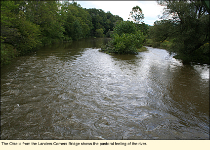
In Cortland County, the only populated area the river flows through is the hamlet of Cincinnatus, the main residential area of the Town of Cincinnatus, population roughly 1100. (Community profile) Much of the river bank area in Cortland County is covered with trees and shrubs, though the river does flow through some farmland. You should find the river pastoral and calming.
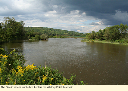
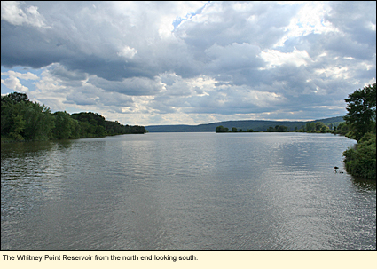
Once the river leaves the county, it soon becomes the Whitney Point Reservoir or Whitney Point Lake due to the damming of the Otselic just north of the Village of Whitney Point. The entire river and lake area are part of the Whitney Point Wildlife Management Area.
Boating
There are no launch sites along the Otselic designed for motorized boats for two reasons: 1) the river is not reliably deep enough for motorboats and 2) the river does have some large rocks that can be dangerous to motorboats. However, the entire length of the river in Cortland County is ideal for canoeing and kayaking, but beware. Canoers and kayakers should not take this river lightly. This is not a lazy river.
The Otselic River in Cortland County is a fast-moving river with some white water over fairly large rocks. It should not be attempted by beginners. And anyone who attempts this river should have some experience with Class I and II white water.
Just above the reservoir, the river calms down. It is here at the north end of the reservoir that one can launch a motorboat for use at the lower end of the river and on the lake. (This area is out of the Finger Lakes region.)
Here are the launch sites.
(Notes: 1) This should not be considered a definitive list. 2) Sites are listed in order of river flow from upriver to downriver.)
State Route 26 Bridge-Cortland-Chenango County Line
On the south side of the road and the east side of the river. Parking for about 4 vehicles. Hand launch only.
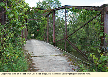
Town Line Road-Town of Taylor
Take Town Line Road east off State Route 26. Go all the way until you see a rusty bridge. Park. Launch is under the bridge on the upriver side. Hand launch only.
Telephone Road Extension Bridge-Hamlet of Cincinnatus
Take Telephone Road Extension east off State Route 26. There is a small park on the down river side of the bridge with steps leading down to the water. Park as close to the grass as possible. Hand launch only.
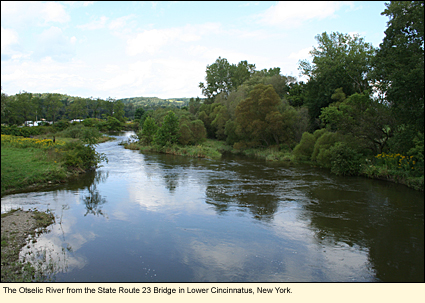
State Route 23 Bridge-Lower Cincinnatus
Take State Route 23 east off State Route 26. Launch area is on the north side of the bridge on the west side of the river down a dirt road to the bank. Hand launch only.
State Route 41/26 Bridge-Willet
Look for a dirt road on the west side of the river and the north side of the bridge. The road may be a bit rutted, so don't go too fast. Park on the mowed grass. Hand launch only.
Landers Corners Road Bridge-Landers Corners
Turn west off State Route 26 onto Landers Corners Road. Drive to the end of the road just before the bridge--approximately .7 mi./1 km. Small parking area. The area is mowed and shaded by trees. It is ideal for a picnic on the grass. Hand launch only. This is the last launch in Cortland County.
Cross over the Landers Corners Road Bridge and turn left onto West River Road (also called Doty Road). Follow this several miles to the end. Turn left onto County Route 152/Upper Lisle Road.
County Road 152/Upper Lisle Road-Upper Lisle
On the left (north) side of the road. Parking for about 4 vehicles. Slight portage to river. The bank is about 3 ft./1 m. high here, and the river is very wide. This is the last launch before the reservoir. Hand launch only. Go around the gate on the right side of the parking area to access a hiking trail.
County Route 152/Upper Lisle Road Bridge-Upper Lisle
On the right (south) side of the road just before the bridge. Large parking lot. Large opening at the lake shore to accommodate motorboats.
Whitewater Classification
The Otselic has no whitewater designation.
Water Level
Streamflow Conditions
Swimming
Although the water is clear and the deep pools can be enticing on a hot day, the swift current can make this river dangerous.
Wildlife
Because of the ruralness of the setting, you are likely to see a wide variety of wildlife, including raccoons, deer, coyotes, foxes, but probably not black bears as this is not good bear habitat. If the water level is low, you may see herons and some reptiles and amphibians. During breeding season, the river bank vegetation should be loaded with birds, including song sparrows, common yellowthroats, catbirds, flycatchers, gnatcatchers, and possibly wrens. Like most of the rivers in the region, the Otselic has trout that migrate up and down the river, depending on the water depth and temperature.
If viewing wildlife is your principal goal, you should make sure to visit County Route 152/Upper Lisle Road where the river runs into the lake. This is part of the Whitney Point Wildlife Management Area. Here there are many parking areas and access to trails near the river and to viewing points of some of the wetlands in the area.
Biking
Cortland County has many roads that are excellent for biking. These include, but are not limited to state routes 11, 13, 26, and 41. (All state highways are paved with a least a 3 ft./1 m. of paved shoulder.) State Route 26 runs "along" the Otselic through all of Cortland County, however, the river may be back from the road much of the time, so there is no way to have a ride along the river with the Otselic. (In fact, State Route 26 begins (or ends) at Alexandria Bay on the Saint Lawrence River and runs to the Pennsylvania state line.) An interesting ride through the Otselic region could be made by creating a circuit using state routes 80, 26, and 11.
The backroads of Cortland County are really back roads with many being unpaved and rather hilly. These are good for mountain biking.
Keep in mind that this is very rural New York, that there are often few services along the way, and that cell phone service cannot be relied upon.
Parks, Forests and Wildlife Management Areas
Baker School House State Forest
Dog Hollow State Forest
Donahue Woods State Forest
Gee Brook State Forest
Hoxie Gorge State Forest
Maxon Creek State Forest
Otselic State Forest
Papish Pond Multiple Use Area
Taylor Valley State Forest
Accommodations
BED AND BREAKFASTS
MOTELS
There are hotels and motels in Cortland and Whitney Point.
Created 2 September 2009
|