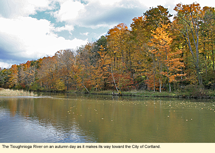
The Tioughnioga River in the Finger Lakes: East Branch
The Tioughnioga River is the home of both Cortland Line and Marathon Boat Group, best known for its Grumman Canoes. The river is divided into two branches. This page deals with the East Branch. To be taken to the West Branch page, click here.
Location
The east branch of the Tioughnioga (pronounced Ty-off-nee-o-ga) River begins east of the Finger Lakes in Madison County, where it is called the Tioughnioga Creek. As the Tioughnioga Creek, it flows into Cortland County and the Finger Lakes, increasing in size with the addition of Labrador Creek at Truxton. Then, as the Tioughnioga River, it works its way southwest to the City of Cortland where it picks up the west branch and makes a slight turn to the southeast. It continues to flow southeast through Cortland County into Broome County where it meets the Chenango River at Chenango Forks.
Physical Features
By the time the Tioughnioga Creek reaches Cortland County and enters the Finger Lakes, it is already a decent-sized creek with a rapid flow. As a creek, it twists and turns considerably, cutting its way through a wide, flat valley, passing through corn fields and by grazing Holsteins and horses. The soil in this region is silty, the remains of glacial till. The river sends the silt downstream, but large rocks scatter themselves throughout the creek bed, causing a certain amount of whitewater. In some places, trees and bushes overhang the banks and ducks and geese cluster in groups feeding.
When the river picks up the west branch in Cortland, it increases in size considerably and straightens out somewhat. The number of rocks in the river increases as does the river's difficulty from a paddling point of view. There are fewer farms in this region because the valley narrows, especially around the Village of Marathon.
Because the valley is so narrow, when it rains, the rain comes down the hills directly into the river. There are also a number of creeks all along the river's length that feed into the river, adding to its flow.
Below Marathon, the river continues to chug along at good speed for a few miles until it crosses over the county line into Broome County and out of the Finger Lakes. At no point during its flow through Cortland County does it slow down enough to create a wetland, though there are places were the river twists and turns enough to create shrubby wet areas. Unlike some of the slower rivers in the region, there is little vegetation growing in the water and certainly no duck weed like in the West River.
A Note About the Region
Whether you're coming to boat, ski, hike, bike, or just take a leisurely drive, there are few services along the river. The three places where you can be sure to find gasoline and food are Deposit (Madison County), the City of Cortland, and the Village of Marathon. There is also a gas station in Tully and a "greasy spoon" in Truxton.
Boating
Notes:
1) The east branch of the Tioughnioga River in Cortland County is not appropriate for motorboats, and there are no launches that accommodate them.
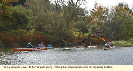
2) The east branch of the Tioughnioga River is considered an intermediate to expert river. Anyone who paddles on this river should have experience with getting wet and many kayakers recommend a skirt. Some use a GPS. When I asked one canoer if he had ever paddled upriver from a particular point, he laughed and responded, "No one paddles upriver on the Tioughnioga."
3) D=State designated access site.
Launch sites are listed in order of flow.
Tripoli Road Bridge--Hamlet of Cuyler
You'll find Tripoli Road (County Road 152B) just off State Route 13. Park on the northwest side of the bridge and launch from the highway department property on the northeast side. No amenities.
State Route 13 (Main Street south of Cuyler) (D)
This site is located on the east side of the road .3 mi./.5 km. south of Crains Mills North Road. Large parking lot. No amenities.
Cheningo Road Bridge-Hamlet of Truxton
Just off State Route 13 next to a ball park called John J. McGraw Field. Park across the road and portage to the creek. Picnic pavilion, portable toilet.
Youngs Crossing Road Bridge (Town Line Road)
Just off State Route 13 midway between Truxton and East Homer. 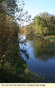 Park on the southeast corner and portage down a slope to the river. No amenities. Park on the southeast corner and portage down a slope to the river. No amenities.
East Homer Crossing Road Bridge-Hamlet of East Homer
Just off State Route 13 on East Homer Crossing Road (County Road 108C). Park on the southeast side of the bridge. Enter from that side. No amenities.
East River Crossing Road Bridge-Hamlet of East River
Just off State Route 13 south of East Homer. Park on the southeast corner of the bridge. Enter from the northwest or southwest corners. No amenities.
Yaman Park-Cortland
The entrance to the park is on Kennedy Parkway on the east side of State Route 13 just north of the intersection of 13 with Interstate 81. Follow the parkway straight into the park, then curve to the right around the swimming and picnic areas to the back of the park. The river runs along here. There is a dedicated parking area with a concrete ramp and dock. The park has supervised swimming, a bathhouse, picnic pavilions, an enclosed skateboard park, a gazebo, a playground, and toilets.
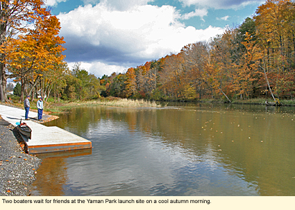
Note: This is probably the most popular launch site along the river for many reasons. The site launches into the river just north of its confluence with the west branch. There is a shopping center on Route 13 just south of 81.
Blodgett Mills Road Bridge-Hamlet of Blodgett Mills (D)
Just off U.S. Route 11. Park on the southwest side of the bridge, enter on the same side. Small parking lot. No amenities.
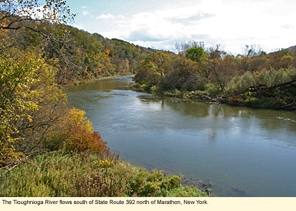
State Route 392 Bridge-Hamlet of Messengerville (D)
Just off U.S. Route 11. There are two parking options. 1) Park in the state-designated parking area on the southeast side of the bridge and enter from that side with a short portage or 2) enter from the northwest side, using a dirt drive that goes all the way to the riverbank. No amenities.
U.S. Route 11-Marathon (D)
This area is 1.2 mi./2 km. north of the intersection of routes 11 and 221 in Marathon. Large parking area. Short portage down a slope to the water. No amenities.
Lovell Field-Village of Marathon
From the intersection of routes 11 and 221 in Marathon, drive one block south on Route 11 (Broome Street) and turn west onto Brink Street. Drive the short distance to the end of the street. The entrance to the park should be on your left. Drive straight into the park about 500 ft./152 m. The river and launch area will be on your right. Concrete ramp and dock. Large parking area. The park has ball fields, portable toilets, a playground, tennis courts, and picnic tables. It is the site of the annual Central New York Maple Festival and the Maple Museum. This is the last launch site in the county.
Race
Cortland Canoe Classic
Canoe and Kayak Rentals
Lighthouse Landing
Whitewater Classification
The Tioughnioga River has no whitewater classification.
Water Level
Streamflow Conditions
Wildlife
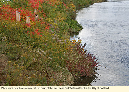
Along the Tioughnioga you may be able to see white-tailed deer, and many small mammals like raccoons, red foxes, and opossums, but you will probably not see animals typical to wetlands like beavers, muskrats, and various reptiles and amphibians. Birds abound in this area. You will see gulls (especially ring-billed), pigeons, crows, and house sparrows feeding in the farm fields, and along the river various hawks, woodpeckers, warblers, vireos, sparrows, ducks as wells as geese, blue jays, cardinals, mourning doves, chickadees, juncos, and more.
Biking
Though there is no dedicated bike route along the river, the valley through which runs the Tioughnioga is great for biking. State Route 13 is listed as a state bike route and has a minimum paved shoulder of 3 ft./1 m. County roads are paved but usually don't have shoulders. Here are two possible routes:
North of Cortland
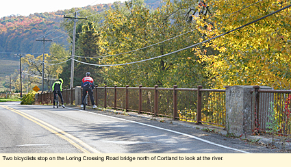
Park at Yaman Park. (The entrance to the park is on Kennedy Parkway on the east side of State Route 13 just north of the intersection of 13 with Interstate 81.) Once parked, ride your bike back to State Route 13 and turn right (north). Ride to Loring Crossing Road and turn right (east). Go to East River Road. Turn left (north). Take East River Road all the way to Cheningo Road and turn left (west, actually it's north, but it seems like west). Follow Cheningo Road to State Route 13. Turn left and follow this back to Yaman Park. The entire ride is just about 20 mi./32 km. Be sure to wear a helmet, and bring something to drink.
South of Cortland
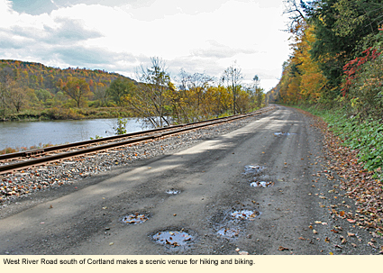
Park in the Blodgett Mills Road Bridge parking lot just off U.S. Route 11. From the parking lot go west to Clute Road. Turn left (south) onto Clute Road. You will soon come to a Y. Bear left onto West River Road. West River Road starts off as a two-line paved road, but the further south you go the more the road narrows. It changes to a one-lane paved road, then a wide dirt road, then finally, a one-lane dirt road. Take this all the way to the end. Turn left (east) onto State Route 392. Cross the river and turn left (north) onto U.S. Route 11. Take this all the way back to Blodgett Mills Road. This is a ride of about 15 mi./24 km. The West River Road section is ideal for hybrid bikes. There are no amenities of any kind on this ride.
Hiking
Unfortunately, there are no hiking trails along the Tioughnioga, however, the Finger Lakes Trail (FLT) runs in an east/west direction and, at one point, runs along West River Road, then crosses over U.S. Route 11 and makes its way through Hoxie Gorge State Forest. To find out more about this section (You will probably want maps M19-20.) of the FLT, check the following Web sites:
Hoxie Gorge State Forest
Finger Lakes Trails Conference
Parks, Forests and Wildlife Management Areas
Cuyler Hill State Forest
Dog Hollow State Forest
Donahue Woods State Forest
Hoxie Gorge State Forest
Maxon Creek State Forest
Nearby Places of Interest (a partial list)
The 1890 House Museum
Cherry Knoll Farm
Cortland Repertory Theatre
Greek Peak Mountain Resort
Hoxie Gorge Nature Preserve
Labrador Mountain
Lime Hollow Center for Environment & Culture
Reakes Country Goods
Accommodations
BED AND BREAKFASTS
Chrysler's Bed & Breakfast
1344 U.S. Route 11
Marathon, NY 13803
607-849-4108
SUNY Cortland Alumni House
29 Tompkins St.
Cortland, NY 13045
607-753-1561
CAMPGROUNDS
Cortland Country Music Park & Campgrounds
State Rt. 13 North
Cortland, NY 13045
607-753-0377
Yellow Lantern Kampground
1770 State Rt. 13 North
Cortland, NY 13045
607-756-2959
Country Hills Campground
1165 Muckey Rd.
Marathon, NY 13803
877-271-9480
Forest Lake Campground
6019 Dog Hollow Rd.
Truxton, NY 13158
607-842-6401
HOTELS AND MOTELS
There are a number of hotels and motels in Cortland.
Created 30 November 2013
|
