- Site Indexes
- Search by Keyword
- Search by Topic
- Search by Place
- Things to Do
- Entertainment
- Recreation
- History
- Basics
- Accommodations
- Have Some Fun
- Fun Stuff
- Kid Stuff
- Food and Recipes
- Send a Postcard
- Wallpaper
- Our Site
- Site Info
- Contact Us
- Home
xxxx
xxxx
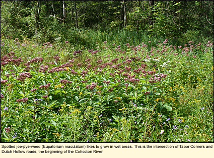
Home > Basics > RiversThe Cohocton River in the Finger LakesLocationThe Cohocton River begins at the intersection of Tabor Corners and Dutch Hollow roads in the Town of Springwater in Livingston County and runs south along Tabor Corners Road into Steuben County where it heads southeast, eventually running into the Tioga River just south of the Village of Painted Post to form the Chemung River. Physical FeaturesWhy is it important to know that the Cohocton begins at the intersection of Tabor Corners and Dutch Hollow roads? Because it is here that passes one of four major continental divides--the St. Lawrence Seaway Divide--causing the Cohocton to flow south and the nearby creeks that feed into Honeoye, Canadice, and Hemlock lakes to flow north.
The Cohocton is a very winding river, making it impossible to determine the river's exact length, however, one could guesstimate that a drop of water starting out at Dutch Hollow Road would have to travel 60 mi./96.5 km. before it met the Tioga River.
The windiness of the river actually helps it to stay clear, a feature for which the river is well known. The river bottom is covered with small stones, its banks are usually shaded with trees, shrubs, and other vegetation. There are a number of small grassy islands in the river that are worth exploring visually but are probably not worth getting out of your boat for.
The Cohocton runs through no large cities and comes into pollution that is mostly from agricultural run-off or run-off from highways that run along side it. HistoryLike most of the rivers in the Finger Lakes region, the Cohocton was used by Indians for transporting people and goods. When Charles Williamson, land agent for the Pulteney Associates in England, began to settle what is now Livingston and Steuben counties, he used wooden rafts on the Cohocton to bring cattle and goods between his second settlement--Bath--to places as far away as Baltimore. The trip took six days, a great savings in time from the trip by wagon, which took weeks. Later, shelters were built on the rafts and these conveyances were called arks. But the Cohocton is not reliably deep all year long, which is one reason why Bath never became a large port city. Animals and goods still had to be transported by wagon during the winter and the summer when the water levels were lowest. Historic BridgesWoods Road Bridge More on the restoration of this bridge. BoatingAlthough the Cohocton has occasional deep pools, the river in general is not deep enough for motorboats and there are no launches along the river to accommodate them. However, the river has probably 30 mi./48 km. or more of water suitable for paddling and rowing.
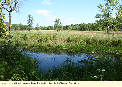
Here are the official and non-official launch sites. (Notes: 1) This should not be considered a definitive list. 2) D=Officially designated launch site. 3) Sites are listed in order of river flow from upriver to downriver.) Lawrence Parks Recreation AreaOn Atlanta Back Road in the Hamlet of Atlanta in the Town of Cohocton, Steuben County. This is a town park with a playground, swimming pool, spray pool, bathhouse, picnic pavilion, ball fields, and nature trails. The river runs at the back of the park and the head lifeguard stated that boat launching is permitted there. Large parking lot.
State Route 371 BridgeThis site is just downriver from the Lawrence Parks Recreation Area where the river runs under the road. Parking lot. Wentworth Road BridgeJust off State Route 415 south of the hamlet of Cohocton. Parking lot. State Route 415 Bridge
Wallace-West Creek RoadMidway between the hamlet of Wallace and the village of Avoca on the west side of the road. You will need to carry your boat through some close vegetation. Large parking lot. Hees Memorial ParkThe park is just north of the village of Avoca. The entrance to the park is on River Street at the intersection of State Route 415. The park is mostly ball fields. Parking lot. State Route 415 BridgeJust south of the village of Avoca at Owens Road. Parking lot, picnic table. Watch for eagles. Knight Settlement Road BridgeAt the intersection of Knight Settlement Road and State Route 415 just before you enter the village of Bath. Parking lot. Cameron Street Bridge, BathThe spot is listed in some publications. It is currently posted as private property with no trespassing. Do not use.
Note: Between the Cameron Street Bridge and the Babcock Hollow Road Bridge, keep an eye on the south bank of the river. There is a utility pole on the edge of the river with an active osprey nest on top.
Babcock Hollow Road Bridge (D)This is the first officially designated boat launch on the river. It is located near the intersection of Eagle Valley Road (off Exit 39 of State Route 17/86) south of the village of Bath. Concrete steps to the water. Parking for several vehicles.
Wood Road Bridge (D)Between Savona-Campbell Road and County Route 125 just north of the hamlet of Campbell. Concrete steps to river. Small parking lot. Campbell Legion Field ParkState Route 333 across from Tannery Road in Campbell. The park is mostly ball fields with a parking lot. The grass is mowed from the parking lot to the river. Smith Hill Road BridgeIn Coopers Plains. The trail to the river is down a fairly steep embankment. Parking for several vehicles. Kinsella Park (D)On Canada Road in the Town of Erwin. This is a town park with ball fields, picnic tables, a pavilion, and toilets. Immediately after this launch site, the river is channeled and then quickly meets the Tioga River to form the Chemung. Do not go downriver from this site unless you want to enter the Chemung. Whitewater ClassificationThe Cohocton has no whitewater designation. Water LevelWildlifeThe Cohocton is a magnet for wildlife. One of the first things one notices about the river is the great number of insects that congregate near the water. Mayflies are plentiful in the spring and dragonflies and damselflies are everywhere with many species being represented. The abundance of insects feeds brook trout and birds like phoebes and swallows. The fish in BikingBicycling the length of the Cohocton can be an interesting and scenic adventure. The river runs along or near State Route 415 much of the way. This road is designated and posted as a state bike route (route number 17). Along here, the road is well paved with paved shoulders at least 3 ft./1 m. wide. Elsewhere there may be no shoulders, but all the roads along the Cohocton are paved.
Bikers should keep several things in mind. Because much of the route along the Cohocton is rural, you may go for long distances without any services. Cell phone service is not reliable in much of the area. Traffic on the roads in the area can be mostly large trucks and other vehicles related to agriculture, business, and industry. A helmet is required for children and recommended for adults.
SwimmingThe clearness of the Cohocton is appealing to many swimmers, however, the river is not deep nor is there any place where there is supervised swimming. Public access for swimming can be had at Kinsella Park on Canada Road in the Town of Erwin. There is no bathhouse, but there are toilets. Parks, Forests and Wildlife Management AreasHarriet Hollister Spencer Memorial Recreation Area Mount Washington Multiple Use Area Nearby Places of InterestThe upper Cohocton is within easy distance of Honeoye, Canadice, and Hemlock lakes. Healing Spirits Herb Farm & Education Center (in Wallace) Spencer Crest Nature Center
AccommodationsBED AND BREAKFASTSBed and breakfasts in Steuben County CAMPINGTumble Hill Campground is just down the road from the Cohocton. There are a number of other campgrounds in Livingston and Steuben counties. MOTELSThere are many hotels and motels in Bath and Painted Post, some quite close to the river.
Created 27 October 2010
|
|
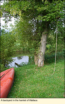 Just south of the hamlet of Wallace on the east side of the road. Parking lot.
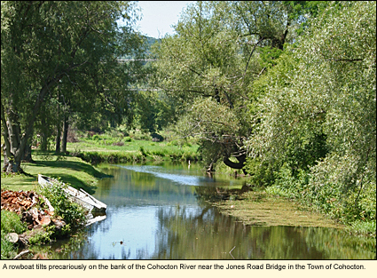
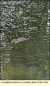 turn attract fish-eating birds like kingfishers, herons, eagles, and ospreys. There are also numerous reptiles and amphibians who breed in the marshy areas that crop up along the river. Larger animals like beavers, mink, muskrats, deer, bear, foxes, and coyotes can also be seen taking advantage of the river's waters.
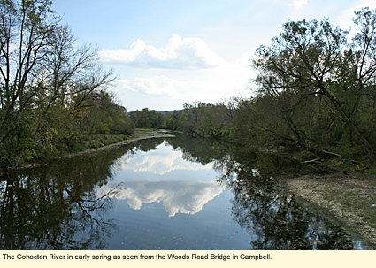
|
|