The Oneida River in the Finger Lakes
Location
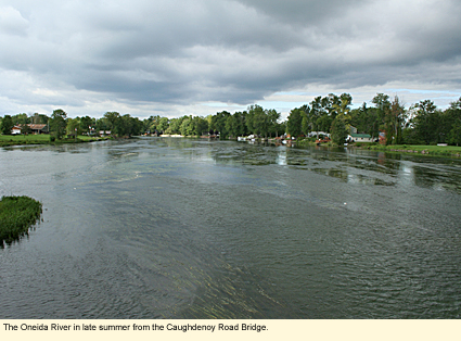
The Oneida River begins as the outlet of Oneida Lake, which lies in Oswego and Oneida counties, though its shoreline is also in Onondaga and Madison counties. The river itself flows generally east to west and is divided down the center with the southern shore being in Onondaga County and the northern shore being in Oswego County. (Of all those counties, only Onondaga is in the Finger Lakes.) The river ends at a place called Three Rivers, where the Oneida and the Seneca rivers come together to form the Oswego, which flows north into Lake Ontario. The largest community along the river is the Hamlet of Brewerton at the northern end of the lake.
Physical Features
The Oneida is a rather wide, flat, and loopy river but not especially long or fast. Its popularity as a boating river and its access to the lake mean that there are many houses along it, but there are also long stretches where the shore is covered with vegetation, mostly of the upland variety (woods with tall trees and a shrubby understory) rather than wetland.
Boating
The Oneida is deep enough to handle traffic from large motorboats as well as canoes and kayaks. Its location between the Seneca River and Oneida Lake and its designation as part of the Erie Canal system means that much of the traffic on the river is through traffic. In theory, one can start at the harbor at Watkins Glen at the southern end of Seneca Lake, boat north up Seneca Lake onto the Cayuga-Seneca Canal, onto Cayuga Lake, onto the Seneca River, onto the Oneida River, and finally onto Oneida Lake without ever touching land.
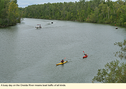
Because the river is a busy waterway and considered part of the Erie Canal system, it is kept free of downed trees. You will probably find no obstructions throughout its entire length.
You can launch from any of many sites on Oneida Lake. Here are the sites specifically on the river following the flow of the river.
Riverfront Park-Brewerton
This is a Town of Cicero park operated by the New York State Canal Corporation. The park is on a short street called Bennett Street, which is the first street to the west on the south shore of the river by the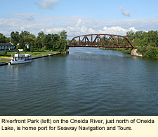 Route 11 bridge. (If you cross over the bridge from north to south, you should be able to see the park below you off to the right.) There is a large parking lot and a concrete ramp that is in the wrong position to be used by boats on trailers. There is also a concrete harbor dock for short-term mooring. Portable toilet. No picnic tables, but there is plenty of grass for a picnic on the lawn. (Note: Technically, the address of the park is 9700 Walnut Street, but this may not help you as it sometimes doesn't show up on address-finding aids.) Route 11 bridge. (If you cross over the bridge from north to south, you should be able to see the park below you off to the right.) There is a large parking lot and a concrete ramp that is in the wrong position to be used by boats on trailers. There is also a concrete harbor dock for short-term mooring. Portable toilet. No picnic tables, but there is plenty of grass for a picnic on the lawn. (Note: Technically, the address of the park is 9700 Walnut Street, but this may not help you as it sometimes doesn't show up on address-finding aids.)
Caughdenoy Road-Caughdenoy
The river flows north from Riverfront Park and then takes a turn to the west near Caughdenoy. There is a levee just before the Caughdenoy Road bridge. For those who are paddling, you must exit on the north shore just before the levee. This is 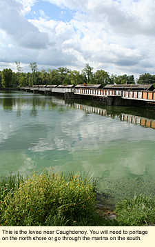 a small hamlet park with picnic tables. (Technically, this park is on County Route 12.) Portage around the levee (this is a matter of just a few feet of portage) and continue on your way. There is a lock here, but it is no longer operational. If you are motorboating, you must go around the levee, using the Caughdenoy Marina on the south shore. If you are going this way, you will not go through Lock 23, which is on the Anthony Cut. (See below.) a small hamlet park with picnic tables. (Technically, this park is on County Route 12.) Portage around the levee (this is a matter of just a few feet of portage) and continue on your way. There is a lock here, but it is no longer operational. If you are motorboating, you must go around the levee, using the Caughdenoy Marina on the south shore. If you are going this way, you will not go through Lock 23, which is on the Anthony Cut. (See below.)
Caughdenoy Road Bridge over Anthony Cut
Large parking area. Steep embankment to the water. Hand launch only.
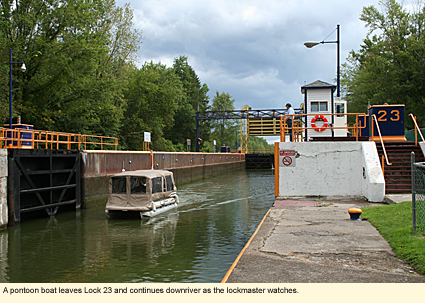
Lock 23-Anthony Cut
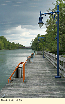
Take Black Creek Road to Lock Road. The lock itself is at the end of the road. The lock has a small park with picnic tables and a portable toilet. At the upriver end of the lock is a lovely, long, wooden dock at the upriver end from which canoes and kayaks may be launched. There is also a short ramp at the downriver end, though it's probably too shallow there to launch a motorboat.
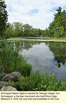
Downriver is Glosky Island. At one time the river made one of its many loops here. Another cut like Anthony's Cut created this island. Next is a small island called Schroeppel Island. Continue downriver to the Morgan Road bridge.
The first house on Morgan Road (County Route 10) on the north side of the river is a gorgeous Greek Revival mansion that operates as a bed and breakfast. Named River Edge, the mansion was built in 1818 and has, along with a private dock on the river, an very interesting past. The mansion is on the National Register of Historic Places. This is the only bed and breakfast right on the river.
Horseshoe Island
Next you will come to a Y in the river at Horseshoe Island, again, another island created by a cut. To the left is the cut and the Horseshoe Island Road Bridge. Cross the bridge to the island. Immediately on the west side of the road is a parking area with a trail down a steep bank to the river. No amenities.
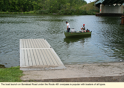
Bonstead Road
Just downriver from the western edge of Horseshoe Island is another launch commonly called the Bonstead Road launch. It is actually located directly under the State Route 481 overpass. This site has a single concrete ramp with a short aluminum dock and parking for at least 20 vehicles with trailers. There are no other amenities. This is the last launch on the river. It is just a short distance down the road from Three Rivers. There is no launch site at Three Rivers.
 Whitewater Classification Whitewater Classification
The Oneida River has no whitewater classification.
Water Level
Streamflow Conditions
Swimming
Swimming in the river is popular and relatively safe as the current is not swift, however, children should be supervised. There are no designated swimming areas on the river.
Wildlife
You are less likely to see a lot of wildlife on the river for two reasons: there is no wetland or marsh along the river to attract animals that like the marshy habitat, and the river can be very busy with boat traffic, which deters wildlife. However, you should be able to still see a wide variety of birds, including kingfishers, herons, ring-billed gulls, ospreys, and perhaps bald eagles, as well as smaller birds in the woods along the river. If you're lucky, you may see a deer, otter, or muskrat swimming in the river. And certainly there are fish, turtles, and amphibians, too.
Biking
There are no bike paths in the area. Bicyclists need to be careful because the area can go from rural to heavily developed quickly, and some of the state routes can be dangerous because of the amount of traffic. Although it's a bit of a drive or boat and not along the Oneida River, one of the nicest biking spots in the area is at the northern end of Onondaga Lake where Onondaga Lake Park and Long Branch Park are linked. Together, they have miles of paved off-road biking, jogging, and in-line skating trails, as well as nature trails. You can get to these parks easily by boat by continuing upriver along the Seneca from Three Rivers for a few miles. When you reach Klein Island, turn left (southeast) into the outlet to Onondaga Lake. Onondaga Lake Park will be on your port side. You can dock here temporarily.
Parks, Forests and Wildlife Management Areas
Cicero Swamp Wildlife Management Area
Hamlin Marsh Wildlife Management Area
Old Erie Canal State Historic Park
Three Rivers Wildlife Management Area
Nearby Places of Interest
 (a partial list) (a partial list)
Heron Marsh
Marie's Woods
Accommodations
MOTELS
Motels and hotels can be found in Brewerton and in the Syracuse area.
Created 10 September 2009
|