- Site Indexes
- Search by Keyword
- Search by Topic
- Search by Place
- Things to Do
- Entertainment
- Recreation
- History
- Basics
- Accommodations
- Have Some Fun
- Fun Stuff
- Kid Stuff
- Food and Recipes
- Send a Postcard
- Wallpaper
- Our Site
- Site Info
- Contact Us
- Home
xxxx
xxx

x
Home > Recreation > BirdingBirding Sites in the Finger LakesCHEMUNG COUNTYHorseheads MarshCoordinates: 42.19004°N 76.83272°W
Habitat: Horseheads Marsh is a long, narrow, wet marsh bisected by railroad tracks. Observation is from the tracks, which are slightly elevated in relation to the marsh. The length of this section of track is 1.4 mi./2.25 km. The first part of the marsh as you start out along the tracks is mostly cattails with a considerable amount of open water. The farther you go along the tracks, the more the habitat becomes populated with trees and shrubs. The types of birds you see changes as you progress along the tracks, making this a relatively short but rewarding place to bird.
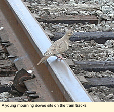
You should be able to see killdeer and mourning doves sitting on the tracks, several species of swallows flying over the wet areas, pied-billed grebes, bitterns, wood ducks, mallards, black ducks,
Season: Spring is the best time to visit the marsh, but summer and autumn can also be good. You need to pick your day and time of day carefully as trains do use these tracks. Sunday seems to be the day when there is no use of the tracks.
Access: The train tracks parallel State Route 14 in the Town of Horseheads near the intersection of Wygant Rd., which is 1.5 mi./2.4 km. north of the business center of the village of Horseheads. Pull over and park just off Wygant Rd. on the western side of the tracks, the south side of the road near the gas station. The marsh will be visible to the SOUTH.
You could also walk the tracks to the NORTH. Cross Wygant Rd. and follow the tracks to the north. The wetland here (mostly on your right or east side) is thicker here with less open water and more cattails and marsh grass. This is the beginning of the Catharine Creek that flows north parallel to State Route 14 and creates the inlet to Seneca Lake. Until recently, the entire railroad right-of-way was bordered with locusts and other trees and overgrown with bushes, especially Japanese honeysuckle. The right-of-way is now being cleared and the tracks re-laid. You will be able to walk next to the tracks for at least .5 mi./.8 km., birding in the bushes and trees along the right-of-way. You should be able to find catbirds, cardinals, and common yellow-throats. Look for Carolina wrens, orioles, red-winged blackbirds, goldfinches, and blue jays.
Notes: 1. The ties used on railroad tracks are coated with coal tar creosote. In addition, there are some small bits of broken glass and coarse stones next to the tracks. This area is really not appropriate for dogs.
2. The series of long, low buildings you see to the east of the south marsh is called the Center at Horseheads Marsh. It is a holding and transfer station for a lot of things shipped into the region by rail. Your visit to the marsh should be done in conjunction with a visit to the Center at Horseheads Marsh grasslands.
Nearby Birding Sites:
Updated 19 September 2010
|
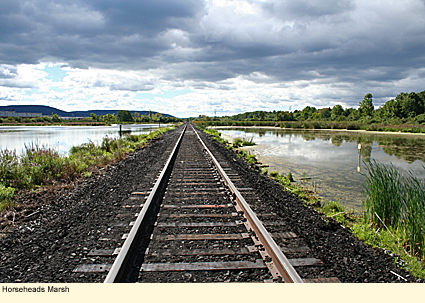
 green- and blue-winged teal, northern shoveler, gadwall, American widgeon, ring-necked ducks, hooded merganser, Canada geese, king and sora rails, coots (moorhen), semi-palmated plovers, greater yellowlegs, several species of sandpiper, dunlin, short-billed dowitcher, snipe, woodcock, flycatchers, herons, blue jays, goldfinches, woodpeckers, hummingbirds, hawks, kingfishers, marsh wrens, palm warblers, northern waterthrush, cardinals, swamp sparrows, red-winged blackbirds, and probably screech owls. What you see depends, of course, on the height of the water and how much muck is exposed. I saw a flock of peeps swooping and diving around the marsh, but there was no place for them to land as the water was too high.
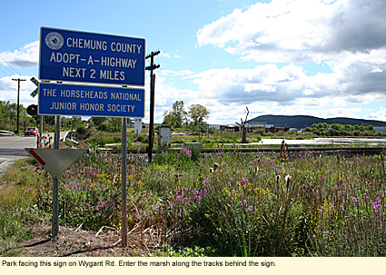
|
|