- Site Indexes
- Search by Keyword
- Search by Topic
- Search by Place
- Things to Do
- Entertainment
- Recreation
- History
- Basics
- Accommodations
- Have Some Fun
- Fun Stuff
- Kid Stuff
- Food and Recipes
- Send a Postcard
- Wallpaper
- Our Site
- Site Info
- Contact Us
- Home
xxxx
xxx

x
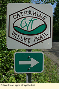
Home > Recreation > State ParksCatharine Valley TrailP.O. Box 304 Watkins Glen, NY 14891 607-535-4511 Services: B,M,O,Y,BB
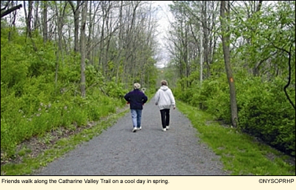
Named for a local Indian Chieftess, the Catharine Valley Trail (CVT) is a work in progress. When completed, it will run approximately 15 miles from Seneca Harbor in the Village of Watkins Glen (Schuyler County) through Catharine Marsh, the Village of Montour Falls, and Mark Twain State Park to Horseheads in Chemung County.
Designed to be a year-round recreation trail, it provides visitors with the opportunity to experience the scenic beauty and historic charm of this glacially-carved region. Following abandoned railroad and canal towpath corridors, the trail passes through a variety of wildlife habitats. The compact stone-dust trail surface accommodates walking, jogging, bicycling, birding, cross-country skiing, and snowshoeing. Pets must be leashed.
The trail is complete all the way from Seneca Harbor to the Millport post office at the intersection of State Route 14 and Burch Hill Road in the Town of Veteran, a distance of about 12 mi./19.3 km. one way.
Here is a description of what you will find. (You can park at any of the trailheads. This description assumes you are parking at the northern-most trailhead--Seneca Harbor.)
Park in the municipal lot at Seneca Harbor. Here, you get a beautiful view of Seneca Lake and the marina. The trailhead is at the intersection of Decatur Street and the harbor parking lot. Ride south on Decatur Street through the village of Watkins Glen, enjoying the many nice homes and churches along the way. Take a left on 12th Street and go around the back of the high school where you will see another CVT kiosk. Follow the trail south through the Catharine Marsh. The Seneca Lake Inlet will be on your left.
At a marked crosswalk, cross over State Route 14 and follow the curving paved path to Genesee St. The trail turns left onto Main
The trail here is flat and shaded with thick vegetation on both sides. You will pass Cook Cemetery on the left. The trail eventually crosses the southern end of Genesee Street where there is another trail head. Once you cross the road, you immediately have the choice of going slightly to the right on the main trail or to the left on a .5 mi./.8 km. spur. Both are interesting, but birders should definitely check out the spur. This runs along a wet area. Here the trees are tall with few low branches. Below the trees is a dense undergrowth of non-native bushes (honeysuckle, multiflora rose, privet, etc.), and the wet area that is mostly cattails.
Back on the main trail, this section runs through a moist woods for 4.5 mi./7.2 km. The trail is high above the Catharine Creek with the dense woods on your right and the steep wooded slope to the creek on your left. The trail is great for beginners as it is marked for distance every quarter mile and has a wooden bench about every half mile. In the late spring and early summer you will see a
The stone-dust trail ends at New Road. Follow this south to the bottom of the hill (about .5 mi./.8 km.). Here it is named Lewis Street, and you are in the village of Millport. At the intersection of Lewis and Maple streets there is a sign indicating that the CVT turns left. If you turn here, you will go to the Millport trailhead at the village park along the Catharine Creek, definitely a nice spot to visit and eat your lunch, but this is not the trail. In order to continue on the trail, you must go straight from Lewis Street onto Morris Hill Road for about .5 mi./.8 km. The trail then goes off through the woods on your left for a short ways, over State Route 14, then along a short paved trail to the Millport post office where there is also parking.
Trail users should be warned that the CVT is becoming extremely popular, not only with local hikers and bikers, but with those from out of state. If you prefer to be alone on the trail, come early in the morning, especially during the week. In the afternoons, especially on the weekends, the trail is very busy to the point of being crowded.
See also Friends of the Catharine Valley Trail and their trail map. Key to ServicesA-Beach B-Biking C-Boat Launch Sites D-Boat Rentals E-Cabins F-Camper Recreation G-Campsites H-Dockage I-Dumping Station J-Empire Passport Accepted K-Fishing L-Food M-Hiking N-Marina O-Nature Trail P-Pavilions Q-Picnic Tables R-Playground S-Playing Fields T-Powerboats U-Recreation Programs V-Showers W-Sledding X-Snowmobiling Y-Snowshoeing Z-Tent/Trailer Sites AA-Vacation Rentals BB-X-Country Skiing CC-Scenic Views DD-All above
Update 17 August 2010
|
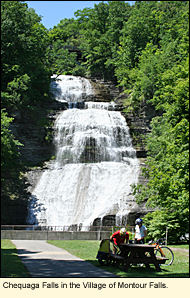 Street, but I like to continue south on Genesee Street and stop at Chequaga Falls for its lovely view. If you do this, continue south on Genesee Street a short ways to Cook Street, turn left and you will meet the trail at the intersection of Cook and Montour streets. If you use Main Street, take a right onto Montour Street and continue the trail from there.
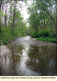 wide variety of wildflowers and ferns, especially maidenhair fern. Birds abound. You should be able to see a wide variety of warblers, thrushes, and vireos, as well as catbirds, cardinals, orioles, red-winged blackbirds, grackles, and some hawks and owls.
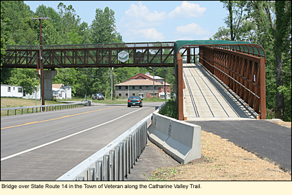
|
|