- Site Indexes
- Search by Keyword
- Search by Topic
- Search by Place
- Things to Do
- Entertainment
- Recreation
- History
- Basics
- Accommodations
- Have Some Fun
- Fun Stuff
- Kid Stuff
- Food and Recipes
- Send a Postcard
- Wallpaper
- Our Site
- Site Info
- Contact Us
- Home
xxxx
xxxx
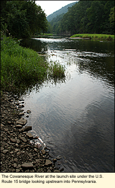
Home > Basics > RiversThe Cowanesque River in the Finger LakesThe Cowanesque (COWA-NES-KEE) River gets its beginning (and end) in Tioga County, Pennsylvannia where it was dammed by the U.S. Army Corps of Engineers and turned it into Cowanesque Lake. Obviously the lake can't hold all the water of the Cowanesque River, so whatever is released by the Army Corps of Engineers flows LocationThe Cowanesque crosses into New York State near the west end of Mill Street in Lawrenceville, Pennsylvania. At this point, the river is technically in the Town of Lindley, New York. It is easiest to find on a map at the point where it crosses under the U.S. Route 15 bridge just north of Lawrenceville. Physical FeaturesFor the mile that the river is in New York State, it is a freeflowing, gently flowing river whose banks are lined with native and non-native trees, shrubs, flowers, and grasses.
The water is generally clear, however, the Army Corps of Engineers dumps/releases silt that has accumulated on the back of the dam into the Cowanesque whenever it pleases. This silt turns the water a dirty brown.
BoatingThis river is good only for kayaking and canoeing. Here are two places where you can put in: U.S. Route 15 Bridge (42°0'6.12"N 77°7'38.06"W)At the south end of the bridge is a car wash. From the parking lot of the car wash is a well-used path down to the water under the bridge. State Street Bridge (41°59'57.47"N 77° 6'55.16"W)From the U.S. Route 15 bridge travel south just a short distance to the first street to the east. This is State Street. Travel to the end of the street where a bridge crosses the Tioga River. On the north side of the street just before you cross the bridge is a space for parking one or two vehicles. Carry your boat down the embankment to the river. You will be putting in just south of the confluence of the Cowanesque and the Tioga. Water LevelThe water level of the Cowanesque is at the whim of the Army Corps of Engineers. When it isn't raining, this is usually about 1 ft./30 cm. Streamflow Conditions (Click on "Tioga River at Lindley") SwimmingThe water of the Cowanesque is certainly clean enough to swim in, but it may not be deep enough for a real good dunk. On the other hand, if you're just interested in getting your feet wet, by all means, take your shoes off! WildlifeThis part of Steuben County is very rural. Watch for birds like the gray catbird, who likes to hide in dense shrubbery, and the great blue heron, who likes to hunt for small fish and frogs while standing in the water. Bears are common in this area and are known to lie in creeks and rivers on hot summer days. AccommodationsBED AND BREAKFASTSThere are no bed and breakfasts along the Cowanesque, however, there are bed and breakfasts in the area. CAMPINGThere are a number of private, and municipal campgrounds in the area but none are directly on the river. The closest campground to the river is the one at Cowanesque Lake. MOTELSThere are no motels in the immediate area. The closest one is probably The Erwin Motel. This would be a good choice if you plan to continue north on the Tioga River.
Created 23 August 2009
|
|
 northeast less than a mile, where it crosses under the historic
 |
|