The Canisteo River in the Finger Lakes
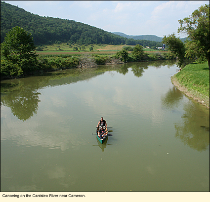
It was 16 August 2009 and, at nearly 90ºF/32ºC, one of the hottest days of the summer. A pair of friends who had put in at West Cameron in Steuben County were taking out a short ways downriver at Cameron. "How far is it from West Cameron to Cameron," I asked. "Twelve beers," the one fellow replied. After laughing, we both agreed it was about 1.5 mi./2.4 km. "How was the trip?" I inquired. "Excellent," he replied. "It's a beautiful day, and the water was just the right height and just the right temperature." The Canisteo aims to please.
Location
The Canisteo runs about 50 mi./80.4 km. beginning in the northeast corner of Allegany County, flowing southeast through most of Steuben County where it meets the Tioga River. It flows through a number of small population centers like Arkport, Hornell, Canisteo, and Addison and even smaller hamlets like Adrian, Rathbone, and Cameron.
History and Physical Features
Along with the Tioga and Cohocton, it is a tributary to the Chemung, which is considered a major tributary to the Susquehanna.
Prior to the American Revolutionary War, the Seneca Indians lived in the region and used the river for transportation. When American and European settlers began to take over the land in 1798, they cut down nearly 70 percent of the trees in the area and began to farm the land.
The Canisteo River runs through a valley bounded by steep hillsides. In the late 1700s, this valley was mostly filled with marsh or wetlands through which the river ran. Yellow fever, a mosquito transmitted viral disease (not malaria, a mosquito transmitted protozoan parasite disease), killed many of the new residents. With so many creeks feeding into it, the Canisteo must have been a powerful river, especially during spring thaws and after heavy rains.
Over the years much of the marsh and wetlands were drained. In fact, the only thing that is left of the Canisteo at the northern end is a broad stretch of farmland (called The Muck) with a narrow ditch (called the Marsh Ditch) running through it. Small remnants of marsh dot the entire valley and hint at what must have been a bountiful and diverse habitat.
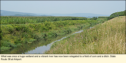
In 1936 a flood occured that devasted many fo the villages and hamlets along the river. The next year the United States Congress passed the Flood Control Act of 1936 that doomed the Canisteo. A dam was constructed above Arkport (called the Arkport Dam) and another dammed the Canacadea Creek (called the Almond Dam) to the southwest of Arkport. The draining, ditching, damming, and channeling of the Canisteo have effectively emasculated the river.
Today a railroad and a highway compete with the Canisteo for space in the valley. But the hillsides are completely treed, creating a beautiful tapestry of color in the autumn, and some of the farmland is reverting to wild land.
The last bridge the river runs under before it meets with the Tioga is the Erwins Bridge on Indian Hills Road. Although the terrain makes it is difficult to launch here, this is a lovely historical bridge you should watch out for as you paddle down the river.
Boating
Kayaking and canoeing are popular activities with the locals, but many people outside the valley don't seem to know about the Canisteo. Boat launch areas are not publicized and there are no formal activities, like there are on the Chemung, to get people interested in river conservation and protection.
Here are the official and non-official launch sites.
(Notes: 1) This should not be considered a definitive list. 2) D=Officially designated launch site. 3) County Route 119 is also known as Canisteo River Road. 4) Sites are listed in order of river flow from upriver to downriver.)
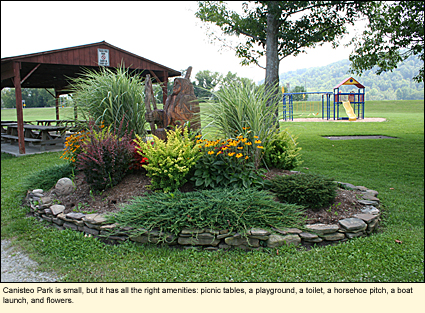
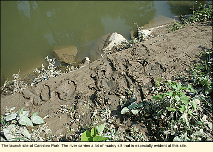
Canisteo Park (D)
42°16.767'N 77°36.739'W
On State Route 36 just north of the village of Canisteo. Pull straight into the park and drive past the pavilion. Continue driving straight across the grass. Park when you see the access sign on your left. This park has a picnic area and a portable toilet.
County Route 119
Just south of the village of Canisteo under a bridge near the intersection of County Route 128 (Canisteo Center Road)
Catatunk Road
In the hamlet of Adrian just off County Route 119 where the river runs under a bridge
McChesney Road
Midway between the hamlets of Adrian and West Cameron just off County Route 119 where the river runs under a bridge
West Cameron
On County Route 119 where the river runs under the road. There is really no parking spot here.
Cameron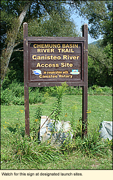
On County Route 22 just off County Route 119 where the river runs under a bridge. Park by the "Welcome to Cameron" sign and go down the embankment to the right of the sign as you face it.
County Route 110 (D)
42°10.717'N 077°21.814'W
In the hamlet of Cameron Mills off County Route 119 where the river runs under a bridge
County Route 21 (D)
42°08.189'N 077°19.239'W
In the hamlet of Rathbone just off County Route 119 where the river runs under a bridge
Village of Addison
Behind the First Heritage Federal Credit Union, 11 Steuben St., Addison, NY 14801. Take the short (100 ft./30.4 m.) road to the west of the credit union and park. You will have to portage over a modest dike. This will be your most downriver launch site.
Erwins (D)
On Mulholland Road just off State Route 417. This is a designated launch site for the Tioga River. The confluence of the Canisteo and the Tioga is .8 mi./1.3 km. upstream.
Water Level
As with any river, the water level varies depending on the amount of rain that has fallen. As a dammed river, the water level also depends on how much water is released from the dams. But, in general, the water level is about 1ft./30 cm. Most locals don't wear a life preserver, however, the closer you get to the Tioga River, the more you should consider keeping one close to hand as the water depth increases here.
Streamflow Conditions
Whitewater Classification
The Canisteo is a Class I-II river in the 20-mi./32-km. section from Canisteo to Addison. Elsewhere it would be considered blackwater. It is calm and good for beginning paddlers.
Swimming
There are very few spots in the Canisteo where the water is deep enough to swim, though it is certainly clean. Consequently, anything other than getting your feet wet is probably left for rivers like the Tioga, Cohocton, and the Chemung.
Wildlife
The Canisteo River basin has all your standard wildlife, everything from white-tail deer to turkeys. Black bears are re-establishing themselves in the region as are bobcats, bald eagles, and other extirpated species. Otters were released along the river in order to re-establsh them, but most of the river probably produces too few fish to support an otter family.
Biking
Like most of the rivers in the region, the Canisteo runs through a broad valley. Two highways (one lane each way) run through these valleys. They are State Routes 36 and 119. They are both well paved with 0 to 3 ft./1 m. shoulders and speed limits of 55 mph. The route is generally winding but there are a few hills. Services are few and far between. Cell phone service cannot be counted on in this area. The ride is scenic and pleasant.
Parks, Forests and Wildlife Management Areas
The following public lands are in (or very near to) the Canisteo River Basin.
Burt Hill Multiple Use Area
Cameron State Forest
Cameron Mills State Forest
Canacadea State Forest
Greenwood State Forest
Helmer Creek Wildlife Managment Area
McCarthy Hill State Forest
Rock Creek State Forest
Tracy Creek State Forest
West Cameron Wildlife Management Area
Stony Brook State Park
Pinnacle State Park and Golf Course
Kanakadea Park
Accommodations
BED AND BREAKFASTS
There are no bed and breakfasts along the Canisteo, however, there are bed and breakfasts in the area.
CAMPING
Camping in state forests is permitted under certain rules. There are a number of private, state, and municipal campgrounds in the area but none are directly on the river.
MOTELS
Hornell is the largest populated area along the river. You can find a list of motels in and around Hornell listed on the Internet.
Updated 2 April 2021
|