- Site Indexes
- Search by Keyword
- Search by Topic
- Search by Place
- Things to Do
- Entertainment
- Recreation
- History
- Basics
- Accommodations
- Have Some Fun
- Fun Stuff
- Kid Stuff
- Food and Recipes
- Send a Postcard
- Wallpaper
- Our Site
- Site Info
- Contact Us
- Home
xxxx
xxx

x
Home > Recreation > State ForestsCliffside State ForestLocationCliffside State Forest is located in the southern part of the Town of Newfield in Tompkins County and the northeastern part of the Town of Cayuta in Schuyler County. Topographical map. HabitatThe forest is 977 acres on a single hill, including the hilltop, which is at about 1,850 ft./563.8 m. The parcel is very irregular in shape and is not marked in any way as state land.
For the most part, the forest is dryish upland with a wide variety of native trees typical to the region. There are some stands of red pine that, over the years, have created an acidic soil in which grow many highbush blueberries. (Watch out for bears when the berries are ripe.)
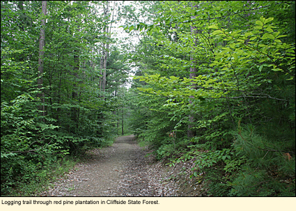
Parts of the site near to the hilltop have been logged in recent years, and this has opened the area to non-native grasses and wildflowers. The logging has created the only trails I saw on the property.
The hill is very steep and has a number of rivulets that drain down it into Cayuta Creek, however, the banks of the gorges are so steep that they are not hike-able. I was told there are no waterfalls on the property.
You should be able to find all the birds, other wildlife, and fungi typical to the area. I didn't see any unusual plants or animals on the property I covered. AccessOn topographical maps, you'll see a jeep trail running from Irish Hill Road west across the hilltop and down the west side of the hill to Morrell Road. The jeep trail at the Morrell Road end is on private property and, having talked to the owner, he does not want to open it for public use. The jeep trail from Irish Hill Road is also on private property, but this is the Arnot Forest (4,000+ acres) owned by Cornell University and is open to the public. You can drive up to the gate across Irish Hill Road, park in the space at the side of the road, and walk around the gate to access the northern portion of Arnot Forest. Continue to walk along the road through the Arnot Forest land due west for less than a mile. You will come to an area in the Arnot that is being logged and can explore all the logging roads. To access Cliffside, continue west through the staging area until you run into some trees. Here, an older logging road curves to your left. This should take you onto the state land, however, again, this isn't marked as such. This old logging road goes downhill for only about a half mile, then, I think, you're on private land again. There are a few spurs from this main trail, but they don't go far. You will definitely need a GPS to stay on state land and not get lost.
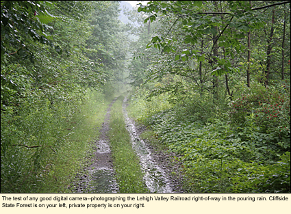
Another "access point" is the Lehigh Valley Railroad right-of-way that runs along State Route 224 in the Town of Cayuta. If you turn north onto a tiny dead-end road called Johnson Road, immediately on your left is the entrance to the right-of-way and a place to park. I don't recommend you drive down the right-of-way as it narrows and there is no place to turn around. However, this is a nice hiking trail. On your right will be Cliffiside, though it isn't marked. However, you're at the base of the hill, and the hillside, as you look at it, rises before you at a 75° angle. The hillside is totally treed with some nice undergrowth and a number of shale outcroppings. I didn't even see any animal trails let alone evidence that humans were climbing there. It looked fairly dangerous to me and certainly not what I would call a "pleasant" outting. The fellow on Morrell Road said that he had entered the forest via a trail that, on topo maps, looks like a creek flows down the hill and out to the tracks. But that was many years ago. I was there and saw no trail. The area was overgrown with bushes and appeared like it might be very wet.
My suggestion is this: You can certainly walk the LVRR right-of-way and enjoy the VIEW of Cliffside. But because the best way to access Cliffside is through the Arnot Forest, and because the Arnot Forest itself offers so many recreational opportunities at any season, it makes no sense to work your way to Cliffside unless you simply wanted to tick it off on a list, saying you had been there. ActivitiesHiking, birding, photography are your best bets. It's probably a good spot to commune with nature. If no one is logging in the Arnot when you're there, you're probably not likely to see or hear another human. Camping is allow, but you may have trouble finding a level spot of ground. There's no appreciable amount of running water. Words to the Wise1. The Scots may have midges, but we have six species of black fly and two types of deer fly, all of which bite. They especially like the face and arms, so take whatever precautions you feel necessary.
2. In the beginning of July the temperature can be 70°F/21°C with 70% humidity. The humidity can be oppressive. Make sure you bring plenty of water.
3. Because of the hills, cell/mobile phones generally don't work in the forest.
4. Although fleas and ticks are few and far between, if you wear shorts, tall socks would be a good thing to wear.
5. A hat would also be nice.
6. So would a compass or GPS.
7. Please don't allow your dog to roam or chase wildlife.
8. Most baby animals that seem to be abandoned are not. Leave them where they are.
9. You are allowed to camp in state forests, but if you plan to stay longer than three nights or are a group, you must have a permit from the regional office of the Department of Environmental Conservation.
Updated 11 August 2008
|
|
|
|