- Site Indexes
- Search by Keyword
- Search by Topic
- Search by Place
- Things to Do
- Entertainment
- Recreation
- History
- Basics
- Accommodations
- Have Some Fun
- Fun Stuff
- Kid Stuff
- Food and Recipes
- Send a Postcard
- Wallpaper
- Our Site
- Site Info
- Contact Us
- Home
xxxx
xxx

x
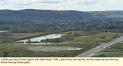
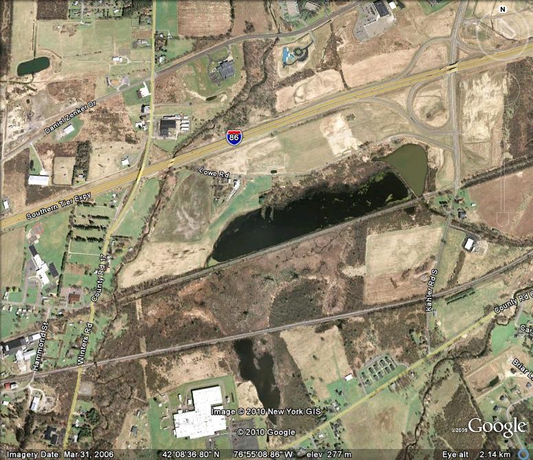
Home > Recreation > BirdingBirding Sites in the Finger LakesCHEMUNG COUNTYLowe's PondKahler Rd. S. Big Flats, NY 14814 Coordinates: 42.084693°N 76.543803°W
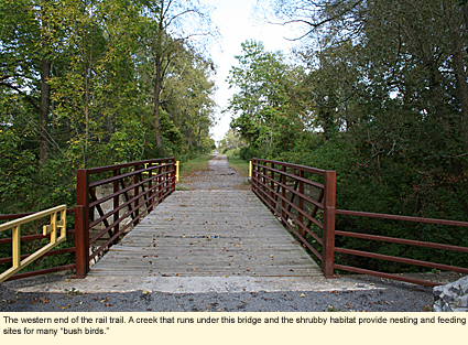
History: A bit of history would help you to understand the site. The pond was named for Cornelius Lowe, who purchased the pond and the surrounding property in about 1804. He built a farm that no longer exists on the north side of the pond on what is now called Lowe Road. Railroad tracks were eventually laid on a constructed rise on the south side of the pond. This rise or berm now separates the pond from an enormous marsh. The railroad tracks were eventually removed and the trail on the south side of the pond became a crushed stone rail trail between Kahler Road and County Road 17 of about 1 mi./1.6 km. in length.
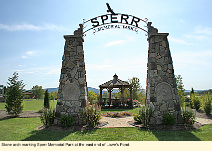
In 2006 a New York State trooper--Anthony J. Sperr--stopped to investigate a car that was parked on Lowe Road, not realizing that the individuals in the vehicle had just robbed a bank. Sperr was shot twice and later died of his wounds. That spot has become a memorial to Sperr, and the eastern end of the pond was turned into Sperr Memorial Park. The park now has an osprey nest platform, bat boxes, a purple martin house, two picnic pavilions and other picnic tables, and a playground.
The pond is known variously as The Lowe Family Ponds, Lowe Pond, and Lowe's Pond. The local historian calls it Lowe's Pond, the name used on this Web site.
Despite the fact that the park is in a relatively rural area, the park and the rail trail can be very busy with joggers, bikers, dog walkers, picnickers, and even wedding reception attendees.
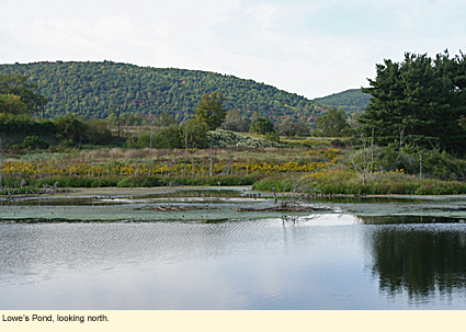
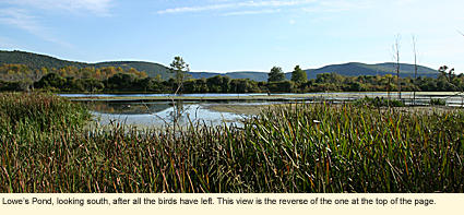
Habitat: The pond is about .8 mi./1.2 km. long and .3 mi./.5 km. wide. The south side of the pond is a steep berm that is overgrown with shrubs, especially Japanese honeysuckle, and other vegetation. The north side is mostly marsh grass with some cattails and other moisture-loving vegetation.
There is an observation deck at the eastern end of the pond. The pond can be seen and scoped from the top of the berm in some spots, though the bushes block the view in others.
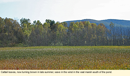
On the other side of the berm along the south side of the pond is a huge marsh more than 1 mi./1.6 km. long and perhaps .6 mi./1 km. wide. It is mostly cattails with some marsh grass and nothing else. There are no trails into this area, though it can be seen and scoped from the top of the berm.
To walk around the pond, park in the small area on Lowe Road. If you want to walk through the park, use the trail that should be in front of you by the memorial. Take that to the left (east). If you'd prefer not to walk through the park, walk further down Lowe Road just a short distant and enter the site using a trail at the back of the equipment shed. This trail goes past the osprey platform and the observation platform. Cross over a small footbridge and turn right onto the rail trail. Walk down the rail trail almost to the end. You will see a metal gate in front of you and a mowed grass path on your right. Take the grass path around the bushes to the right. Trees and bushes will be on your right and a mowed field will be on your left. Walk along the edge of this field until you come to the pond. You will notice that the vegetation changes from course vegetation like golden rod to marsh grass. Walk along this natural division (it isn't wet) until you come to a spit of land that juts out a short distance into the pond. There should be a tree line going back from the spit with several white pines in a row. Backtrack slightly so that you are now walking so that the tree line is on your right. You should be in touching distant of the pines. Stay close to the trees and follow it as it curves around. It will take you out to Lowe Road. Turn right, and walk back to where you parked.
What will happen if you walk around the pond? You might see some interesting birds. There is a Carolina wren, for example, in the bushes next to the mowed field. If you walk this area in the morning, you'll probably get your feet and pants wet. You may have noticed that the birds tend to stick to the northern half of the pond and have a low tolerance even for the joggers and dog walkers. As you leave the mowed field and enter near the marsh grass, you'll find that the birds will squawk and move away, not to the south side of the pond, but toward the east. Once you reach the spit, their tolerance for your presence will have been reached, and they will get up and fly away. Yes, it is possible to walk around the pond, but give careful consideration as to whether you need to or not.
Seasons: Spring will be best, summer will be good, and early autumn will provide you with some waterfowl, herons, and osprey as well as a nice selection of "bush birds" at the western end of the rail trail. Besides those mentioned above, look for grebes, especially pied-billed; bittern; herons; Canada geese; puddle and lake ducks like mallards, blue- and green-winged teal, black ducks, pintails, gadwall, American widgeon, buffleheads, mergansers, and northern shoveler; Virginia and Sora rails; coots; moorhens; semi-palmated plovers; greater yellowlegs; solitary sandpiper; flycatchers; wrens; northern waterthrush; sparrows, including swamp sparrows; red-winged blackbirds (and, perhaps, rusty); and a variety of common birds like blue jays, chickadees, robins, catbirds, and cardinals.
Access: If you take State Route 17/86, you should get off at exit 50 (Kahler Rd.). Turn south. The entrance to Lowe Road and the park should be the first things you see on your right. There are three parking areas at this site: Lowe Road, Kahler Road, and County Road 17, which is at the western end of the rail trail.
Nearby Birding Sites: Center at Horseheads Marsh Grasslands
Created 22 September 2010
|

|
|