The West River in the Finger Lakes
Location
The West River begins in the Hamlet of Granger in the Town of Gorham in Ontario County. It travels southwest into Yates County, generally parallelling State Route 245. (This route is on the east 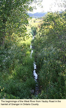 side of Canandaigua Lake. There is no East River.) At the southeast end of Canandaigua Lake, the river curves around the base of South Hill (elevation 1900 ft./579 m.) through a marshy area and enters Canandaigua Lake. The West River is considered the inlet to the lake, though there are a few creeks that feed into the southern end of the lake as well. side of Canandaigua Lake. There is no East River.) At the southeast end of Canandaigua Lake, the river curves around the base of South Hill (elevation 1900 ft./579 m.) through a marshy area and enters Canandaigua Lake. The West River is considered the inlet to the lake, though there are a few creeks that feed into the southern end of the lake as well.
Physical Features
The West River has some distinct physical features that distinguish it from other rivers in the region. A relatively short river, the West is so small for most of its length that it is nothing more than a small creek or stream. Once the river is wide enough to be boatable, it is so slow that many people doubt, in looking at it, that it has a current. This slow current makes the river boatable in either direction, however, because of the lack of current, it is often filled with vegetation to such an extent that motorboaters don't want to bother with it and paddlers find it too tiring. By summer the surface of the water is totally covered with duckweed.
Finally, at the southern end of Canandaigua Lake, the West River flows through a marshy area that has many low islands covered with native trees (maples mostly), shrubs, and other vegetation, as well as huge stands of cattails. Although these areas can be a mecca for wildlife, they can act like pieces of a puzzle, leaving the boater feeling lost. The river is so shallow--only about 3 ft./1 m. where it enters the lake--that it might be better if boating trails were marked through all the vegetation. of Canandaigua Lake, the West River flows through a marshy area that has many low islands covered with native trees (maples mostly), shrubs, and other vegetation, as well as huge stands of cattails. Although these areas can be a mecca for wildlife, they can act like pieces of a puzzle, leaving the boater feeling lost. The river is so shallow--only about 3 ft./1 m. where it enters the lake--that it might be better if boating trails were marked through all the vegetation.
Boating
From certain perspectives the West River is best boated in the spring, when vegetation doesn't clog the water. However, the best time for seeing wildlife is probably in the late spring when water levels will be lower. In late summer, many of the animals are gone, but the leaves on the maples have begun to turn red, making the area quite lovely.
Your choice of launch sites on the river is limited to two only because the amount of boatable river is so short. Brochure
Sunnyside Road Bridge
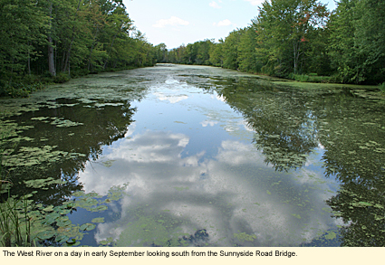
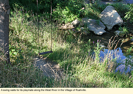
Turn west off State Route 245 onto Sunnyside Road in the Town of 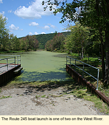 Middlesex. Go less than a mile until the road crosses over a large wet area. (See photo at top of page.) Park on the south side of the road. Parking for 4-5 vehicles. No amenities. Hand launch only. Middlesex. Go less than a mile until the road crosses over a large wet area. (See photo at top of page.) Park on the south side of the road. Parking for 4-5 vehicles. No amenities. Hand launch only.
State Route 245
This launch site is less than a mile south of the Sunnyside Road Bridge launch. A large site, it has a two-tiered parking area, concrete ramp, and portable toilet. No picnic table, but there is shade for eating on the grass.
If you choose to launch into the lake:
State Route 21
At the southwest corner of the lake on State Route 21 in the Hamlet of Woodville. Concrete ramp, toilets, picnic tables. Parking for 80 vehicles and trailers.
To get to the river from the lake:
This might seem like an easy thing to do, however, the small islands of vegetation can look like one large mass from a distance. Head for the middle of the southern end of the lake. You will see a cluster of tall trees. The river actually enters the lake on the west side of this cluster. Shortly after you enter the river, it splits in a Y shape. Whichever direction you take, both will eventually take you in the direction of the launch on State Route 245 (upriver).
A note about Naples Creek:
Some publications recommend that you launch from Naples Creek on State Route 21. Naples Creek is a small creek even at the best of times. It is littered by downed trees and totally impossible to navigate with a boat of any kind.
Marinas
There are no marinas on the river, however, there are many marinas on Canandaigua Lake.
Whitewater Classification
The West River has no whitewater classification.
Water Level
Streamflow Conditions
Swimming
Although the water in the river is not dirty, it is shallow and the bottom is very silty. Better to swim in the deeper parts of Canandaigua Lake.
Wildlife
You should be able to see and hear a variety of reptiles and amphibians, as well as a wide variety of birds, including herons, red-winged blackbirds, bitterns, sedge wrens, wood ducks, mallards, teals, black ducks, and rails. Otters are known to frequent the river and the marsh. You may see bald eagles, osprey, and ring-billed gulls fishing in the lake.
On-Road Biking
There are many biking options near the river depending on your ability. For on-road touring, you can ride State Route 364 from the intersection of Routes 5 & 20 in Canandaigua at the northern end of the lake all the way along the east side of the lake into Middlesex. Here you can continue on 364 to Penn Yan and then take State Route 54 to Seneca Lake or State Route 54A to Keuka Lake. You can also get on State Route 245 in Middlesex and continue south along the West River into Naples. You could then connect with State Route 21 and head north back up to Canandaigua along the west side of the lake. All state roads are paved with paved shoulders.
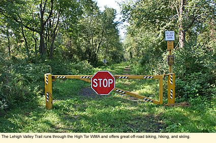
Off-Road Biking/Hiking
If you like off-road biking or hiking, you should try the Lehigh Valley Railroad right-of-way, which runs through High Tor Fish and Wildlife Management Area in three sections.
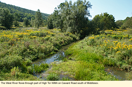
Caward Cross Road (which crosses over the West River several miles south of Middlesex) to Sunnyside Road--3.0 mi./4.8 km.
Sunnyside Road to Parish Road--2.6 mi./4.1 km.
Parish Road to State Route 21 (just north of Naples on the east side of the road)--1.2 mi./1.9 km.
Each section is marked by a metal gate with a stop sign on it. The trail is mowed grass and slopes downhill from north to south. There are no amenities along the trail. In the winter, this trail is excellent for cross-country skiing and snowshoeing.
Parks, Forests and Wildlife Management Areas
Bare Hill Unique Area
High Tor Fish and Wildlife Management Area
Italy Hill State Forest
Nearby Places of Interest (a partial list)
Canandaigua Wine Trail
Great Hill Nature Preserve
Clark's Gully See also
Conklin Gully
Grimes Glen
Sonnenberg Gardens & Mansion State Historic Park
Tannery Creek Glen
Accommodations
BED AND BREAKFASTS
There are no bed and breakfast right on the river, however, there are many in Ontario and Yates counties.
CAMPING
There are no campgrounds on the river, however there are many campgrounds in Ontario and Yates counties.
MOTELS
There are many motels and hotels in Naples and Canandaigua.
Created 9 September 2009
|
