- Site Indexes
- Search by Keyword
- Search by Topic
- Search by Place
- Things to Do
- Entertainment
- Recreation
- History
- Basics
- Accommodations
- Have Some Fun
- Fun Stuff
- Kid Stuff
- Food and Recipes
- Send a Postcard
- Wallpaper
- Our Site
- Site Info
- Contact Us
- Home
xxxx
xxx

x
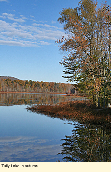
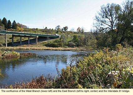
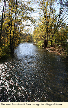
Home > Basics > RiversThe Tioughnioga River in the Finger Lakes: West BranchThe Tioughnioga River is the home of both Cortland Line and Marathon Boat Group, best known for its Grumman Canoes. The river is divided into two branches. This page deals with the West Branch. To be taken to the East Branch page, click here. LocationThe West Branch begins in a wet area in the Town of Tully in Onondaga County just east of the Village of Tully on the south side of State Route 80. It travels as a freshette into Cortland County where it flows into Tully Lake. It becomes the outlet of Tully Lake as it flows under Song Lake Crossing Road into a wetland. It continues more or less in a southerly direction through various shrubby wetlands, Goodale Lake, Upper Little York and Lower Little York lakes in the Hamlet of Little York, the Town and Village of Homer. and on into the City of Cortland where it meets and is taken over by the East Branch. Physical FeaturesThe West Branch runs through a broad and silty valley called the Tioughnioga Valley through which also run a number of highways, including Interstate 81, state routes 281 and 41, and U. S. Route 11. At one time, these roads were Indian trails to and fr
Thousands of years ago, a large glacier left ice in depressions along this corridor. When the ice melted, these depressions became a series of lakes that now include Crooked, Song, Green, Tully, Tracy, upper and lower Little York, and Goodale, as well as a number of smaller, unnamed kettles.
Very little is at sea level in the Finger Lakes, and all of these glacial lakes are at about 1,200 ft./366 m. The hills that border the valleys are all rounded, and most are wooded, privately owned, unnamed, and undeveloped. Two in Preble are named though: Mount Toppin (1,800 ft./545 m.) and Song Mountain (1,900 ft./579 m.). Song Mountain is the site of a popular ski area.
The water in the west branch is clear, but not necessarily clean. The valley is used for agriculture with the main crop being corn to feed the many cows that reside at farms that line the riverbanks. Some of these farms are small and allow the cows to graze (and defecate) right along the river while others are huge farms with more than a thousand cows housed in long pole barns. Still the waste from all these animals must be dealt with.
Although the river runs through a wide, flat valley covered with farms, much of the riverbanks are lined with dense trees, shrubs, and other native plants, remnants of the vast forest that once filled the valley. These moisture-tolerant plants create, from time to time, scrubby wetlands that provide a home to many wild animals.
Through the water one can see, in the early stages of the river, cobblestones like those that line the Lake Ontario shore. The further south the river flows, the larger the rocks become and the more the river has patches of whitewater.
For the most part, the river is rural in nature, but it does run through the Village of Homer, a village of considerable architectural interest and beauty listed on the National Register of Historic Places, and along the northern edge of the City of Cortland, home to a branch the State University of New York.
All too soon--about 14 mi./22.5 km. in fact--the West Branch meets the East Branch as the Tioughnioga heads south along U.S. Route 11.
BoatingAlthough there are many bridges that pass over the West Branch, most of these are rural bridges on town roads that provide no place for launching a canoe or kayak. But there are a few launch sites that are listed below in order of flow. Remember that, like the East Branch, the West Branch has a fairly swift current and some small patches of whitewater. Therefore, the river is not recommended for inexperienced paddlers.
Currie Road Bridge-Town of Preble Currie Road runs between State Route 281 and U.S. Route11. The river here is nothing more than a creek, but is good for people who like to take their time and explore. This route may be littered with downed trees and brush as the area is rather "wild." The next road south is Preble Road, which also runs between 281 and 11, but this is not a good place to put in or take out for various reasons, so you may have to paddle back upriver to Currie Road. The Currie Road bridge spot has parking for 2 vehicles and no amenities.
Durkee Memorial Park-Town of Homer The town park is on U.S. Route 11 just north of the Village of Homer. There are
George Vernum Park-Village of Homer This village park is just a short distance south of Durkee Memorial Park and is mentioned here just in case you need to put out unexpectedly as it is a valid site. The park is located on Main Street (U.S. Route 11) in the village. The driveway to the park is on the south side of the fire station and leads you to a parking lot near a large, enclosed pavilion. A short, paved path leads to the water. Basketball court. No other amenities.
Riverside Plaza-Cortland The entrance to the plaza is just south of the Interstate 81 overpass on the west side of State Route 13. The river runs along the south side of the plaza parking lot. Locate the gravel walk and park in the lot near the walk. The portage is short. There are no specific amenities at the water, but the plaza has a grocery store, eateries, and other stores. The river runs only about .75 mi./1.2 km. further to the east and then meets with the East Branch. The plaza is a logical exit point after a launch at Durkee Memorial Park. The plaza is on the north bank and is set back so that you might not see it if you're down on the water. If you see the New York State Grange building on the south bank, you've gone about 200 ft./61 m. beyond your exit point. Whitewater ClassificationThe river has no whitewater classification. Water LevelWildlifeYou may be able to spot mammals both large and small near the river, but reptiles and amphibians will probably be more illusive due to the current, cool water, and lack of appropriate habitat along the river. Your best chance to see wildlife will be the many bird species that can be found in, on, and along the river.
At the beginning of the river, look for red-winged blackbirds and other small birds that like nesting in shrubby wetlands. Great blue herons, too, will be standing in the water looking for small fish and frogs. Herons will also be just below the Durkee Memorial Park in Homer where the water is a little choppy. They like small fish that feed in this type of water. The woods along the river will have a variety of birds, especially woodpeckers, blue jays, chickadees, warblers, and vireos. Waterfowl will use the river, especially during migration. Common mergansers, for example, can sometimes be seen near the confluence of the east and west branches. BikingThere are no bike trails along the West Branch, however, both of the state highways--281 and 41--as well as U.S. Route 11 are excellent for biking with paved shoulders. (Be sure to wear a helmet.) A nice ride can be had by starting at Durkee Memorial Park on Route 11 in Homer and riding north to Song Lake Crossing Road. Turn left (west) on Song Lake Crossing Road and left again (south) onto State Route 281. Continue south to the intersection of state routes 281 and 41. Turn left (east). Ride 41 until it intersects with 11 in Homer. Turn left (north), and that will take you right back to the park. The ride is about 20 miles. HikingUnfortunately, there are no hiking trails anywhere in this region. Parks, Forests and Wildlife Management AreasNearby Places of Interest (a partial list)Frog Pond Farm Folk Art Gallery Accommodations on the RiverBED AND BREAKFASTSQuagmire Manor Bed & Breakfast 5324 State Route 281 Homer, NY 13077 607-749-2844 CAMPINGThere are no campgrounds on the river, but there are a number of campgrounds in Cortland County. HOTELS AND MOTELSBudget Inn, Ramada Inn, and Hampton Inn are all located along the river, but they are all at the southern end in or near Cortland.
Updated 1 November 2009
|
 om the Onondaga village, which is now accessed by Route 11 at the northern end of the valley.
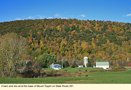
 two ponds. Launch into the southern pond and head south. Picnic tables, pavilion, playground, portable toilets. No swimming.
|
|