The Clyde River in the Finger Lakes
Location
The Clyde is a fairly short river that has lost its identity. It probably never resembled its Scottish namesake and now has trouble resembling a river.
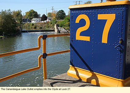
The Clyde River begins in the Wayne County town of Lyons where several creeks, including the Canandaigua Lake Outlet, come together near Lock 27 of the Erie Canal. The river/canal takes a significant dip southward as it heads into the Town of Galen. Near Schwab Road the river and the canal split, both curving northward, but the canal flows straight while the river twists and turns through silty bottomland. The two come together again near the Village of Clyde, and this process of connecting and separating continue as the two flow south into the Seneca County town of Tyre. The river/canal flows through the northern part of Montezuma National Wildlife Refuge and, heading east, flows into the Seneca River. Thus ends the Clyde.
History and Physical Features
Once upon a time, the Clyde was named the Canandarque and was the outlet of Canandarque Lake, which is now the Canandaigua. The Canandarque River ran north from the northern end of Canandarque Lake to what is now Lyons where it met with Mud Creek. Much larger then, the river made a dip south and then headed southeast toward what is now Montezuma National Wildlife Refuge for a rendezvous with the Seneca River.
The problem is that when the Erie Canal was built 1918, it either diverted much of the Clyde's water or took over the river completely. The Erie Canal is a wide, fairly deep channel that can accommodate motorboats and large sailboats (so long as the mast can be lowered as the boat goes under low bridges). The section of the canal that runs between Lyons and the Seneca River flows through three locks--27, 26, and 25--with a rather steady, free flow.
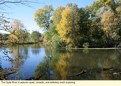
The Clyde River, on the other hand, with much of its water diverted into the Erie Canal, looks more like a congested creek in spots. This is made worse by the fact that tree tops have fallen into the river and haven't been removed. (This is particularly true along the River Road section in the town of Galen.
In addition, to construct the Erie Canal, many "cuts" were made. Cuts are channels through land that create islands, allowing water to flow straight on the canal side of the island while the river curves on the other. (Howland Island is one of many examples of an island having been created by an Erie Canal "cut.") These islands and the debris that has accumulated in the river slow down the river's flow and make paddling difficult in some places. Nevertheless, these sections of true river can be rather quiet, romantic spots with very few houses and thick vegetation hanging over the banks. They attract much wildlife and deserve investigation by paddlers who are less interested in speed and distance than being inspired by nature.
Neither the canal nor the river are muddy, but the color of the water is dark. Since Canandaigua Lake is a mid-sized lake for the region and the canal is rather slow moving, one can anticipate that the temperature of the water will be relatively warm and that the aquatic life in the water will be that which enjoys warm water.
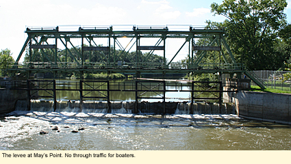
Finally, when the Clyde River runs through Montezuma at a spot called May's Point, it is leveed in order to flood the refuge. The little bit of the river/creek that runs east of the levee before it meets with the Seneca River is congested with trees, making a boat trip along the Clyde to its confluence with the Seneca impossible. However, one can pass through Lock 25 of the Erie Canal and meet the Seneca River just a short way downstream. Technically, it is possible to paddle or motor all the way from Lock 27 in Lyons (or even further up the canal than that) all the way to where the Seneca meets the Oswego River at Three Rivers because the Seneca has met the same fate as the Clyde in that it has been channelized into the Erie Canal.
Boating
Here are the launch sites for the Erie Canal and the Clyde River in order of flow.
Abbey Park
17 W. Water St., Lyons
County park with picnic area, pavilion, playground, toilets, concrete ramp, and dock. Large parking area.
Lock 27
State Route 14, Lyons
Enter the lock by a short road off State Route 14 at the bridge over the canal. Ramp, picnic area. Large parking lot.
Creager Bridge
On Lyons-Marengo Road in the Town of Galen just south of the intersection of Ganz Road. On south side of canal, take dirt drive. Keep circling back toward the bridge until the drive ends. Hand launch only. 1-2 cars. Drive is heavily rutted.
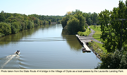
Lauraville Landing Park-Village of Clyde
Take Redfield Street off State Route 414 just south of the bridge over the canal. Turn right onto Orchard Street. Go to the end. The park will be in front of you. Picnic area, portable toilet, 1 dock area and 1 concrete ramp. Water and electric available. Parking area.
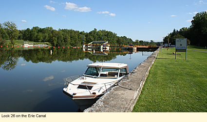
Lock 26
From State Route 414 just south of the bridge over the canal in Clyde, take Redfield Street southeast. It becomes Burrall Street, then Tyre Road. Drive off Tyre Road onto a dirt road when you see a large pond surrounded by stones. Follow the dirt road to the lock. Picnic area, portable toilet, docking area, parking lot.
Armitage Road bridge over the Erie Canal
Armitage Road is the county line road off State Route 89. It can also be accessed from Tyre Road. Launches on both east and west banks on the upstream side of the bridge. Small parking lot at each launch. Hand launch only.
Armitage Road bridge over the Clyde
Just a short distance to the west of the previous launch. Hand launch only from the west bank upstream. 1-2 cars. This is the last launch before May's Point. You will either have to continue via the Erie Canal or exit above the levee.
Marinas
Miller's Marina
185 W. Water St.
Lyons, NY 14489
315-946-9363
Whitewater Classification
The Clyde has no whitewater classification.
Water Level
Streamflow Conditions
Swimming
There is no supervised swimming anywhere along the Erie or the Clyde. However, the locals do have certain places they like to swim, and one of them is underneath the State Route 89 bridge as it passes over the Erie Canal at Lock 25.
Wildlife
Along the Erie Canal part of the river, you are likely to see all of the animals familiar to the canal, especially raccoons, mink, perhaps otters, a turtle or two and lots of birds. The closer you get to Montezuma National Wildlife Refuge the more likely you are to see ospreys, eagles, and egrets. On the Clyde part of the river, because it's so slow, you are more likely to see wildlife typical to ponds like wood ducks and perhaps muskrats and beavers.
Biking
Much of the Erie Canalway Trail is off road, providing a pleasant path along the canal on which to bike and hike. That's not the case with the section of the trail through this part of Wayne County. Here, there is no hiking and the bike ride is along State Route 31, a well-paved route with paved shoulders. The ride is rural and passes by the old Erie Canal. One of the best guides to biking the Erie Canal is Cycling the Erie Canal. You can purchase this map-filled guide from Parks & Trails New York.
Parks, Forests and Wildlife Management Areas
Black Brook Park (9472 Old Route 31, Clyde, NY 14433)
Blue Cut Nature Center (7210 State Route 31, Lyons, NY 14489)
Galen Fish and Wildlife Management Area
Lock Berlin Park (9121 Peters Rd., Lyons, NY 14489)
Montezuma National Wildlife Refuge
Nearby Places of Interest (a partial list)
The Apple Shed
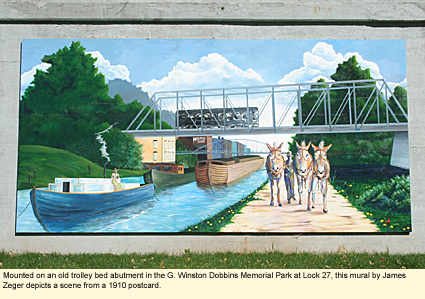
Mural Mania
Port Bay Golf Club
Thorpe Vineyard
Wayne County Historical Society
Wayne Hills Country Club
Accommodations
BED AND BREAKFASTS
There are no bed and breakfasts right on the river or the canal, however, the bed and breakfasts listed for Lyons and Clyde here are all nearby.
CAMPING
Galen Fish and Wildlife Management Area
MOTELS
You can find motels and hotels in Lyons, Newark, Geneva, and Seneca Falls.
Created 7 September 2009
|