Whitewater in the Finger Lakes
If you enjoy the challenge and exhilaration of whitewater, you've come to the right place. The Finger Lakes has nearly two dozen whitewater locations from which to choose. But whitewater rafting and kayaking are seasonal activities, dependent on winter snows and late summer rains. Only one location, the Genesee River at Rock Park, can be considered a year-round whitewater opportunity. The best times to whitewater are in March just after the winter snows have melted and in September just after the summer rains in late August. But don't despair, the Finger Lakes gets plenty of rain in the spring and summer, and after a downpour you may find there's just enough to fill your favorite creek or river for yet another trip through the rapids.
For information about renting equipment, click here.
Using the GPS coordinates: You can use these coordinates easily by going to Google Maps, click on "satellite" on the map, paste the entire coordinate into the search box, and click "Search Maps." Google should show you the exact site. You can click other buttons to see area roads and get directions.
See also: American Whitewater and RiverFacts.com
GUIDED RAFTING TOURS
Adventure Calls Outfitters
P.O. Box 391
LeRoy, NY 14482
888-270-2410
SELF-GUIDED KAYAKING AND CANOEING TOURS
Canandaigua Outlet (Littleville to Manchester)
Class: II-III
Distance: 2.3 mi./3.7 km.
Put-in Location: 42.93947ºN 77.22207ºW
Take-out Location: 42.95964ºN 77.22616ºW
Note: This is a dammed waterway with controlled releases.
Canaseraga Creek
Class: IV-V
Distance: 8 mi./12.8 km.
Put-in Location: 42.46277ºN 77.77084ºW
Take-out Location: 42.54777ºN 77.7064ºW
Nearby: Sugar Creek, Keshegua Creek
Canisteo River
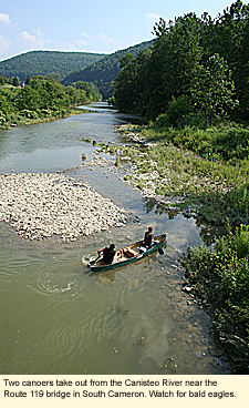 Class: I-II Class: I-II
Distance: 20 mi./32 km.
Put-in Location: 42.27569ºN 77.6017ºW
Take-out Location: 42.10649ºN 77.2333ºW
Note: This waterway is dammed by the Arkport Dam in Arkport, New York and has controlled releases. For more information about the river, click here.
Cascadilla Creek
Class: V
Distance: 2 mi./3.2 km.
Put-in Location: 42.44319ºN 76.4767ºW
Take-out Location: 42.45059ºN 76.50461ºW
Nearby: Fall Creek, Six Mile Creek, Salmon Creek, Taughannock Creek
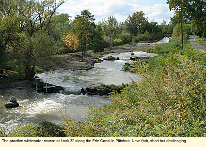
Class: II+
Distance: .5 mi./.8 km.
Put-in Location: 43.09099ºN 77.54551ºW
Take-out Location: 43.0909ºN 77.54441ºW
Note: This is a constructed course designed for use by the U. S. Olympic kayaking team. It is short but challenging, a good course for practicing technique. Water is available only during the regular canal season, which is determined every year by the New York State Canal Corporation and may vary slightly from year to year but usually from the beginning of May to mid-November. Since it is right next to the Erie Canal, once finished with the course, you can take a leisurely paddle on the Canal.
Nearby: Irondequoit Creek
Fall Creek (Etna to Forest Home)
Class: II-III
Distance: 8 mi./12.8 km.
Put-in Location: 42.4886ºN 76.37723ºW
Take-out Location: 42.45083ºN 76.46889ºW
Note: Fall Creek runs through the towns of Dryden and Ithaca and the City of Ithaca before flowing into Cayuga Lake.
Nearby: Cascadilla Creek, Six Mile Creek, Salmon Creek, Taughannock Creek
Fall Creek (Route 13 Bridge to Cornell Plantations)
Class: II
Distance: 6 mi./9.6 km.
Put-in Location: 42.47138ºN 76.41834ºW
Take-out Location: 42.45055ºN 76.46667ºW
Nearby: Cascadilla Creek, Six Mile Creek, Salmon Creek, Taughannock Creek
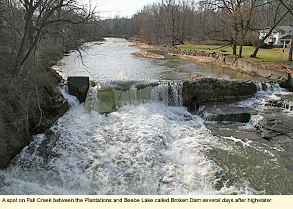
Fall Creek (Cornell Plantations to Beebe Lake)
Class: IV-V
Distance: 1 mi./1.6 km.
Put-in Location: 42.45479ºN 76.4555ºW
Take-out Location: 42.45149ºN 76.4734ºW
Note #1: http://americanwhitewater.org/content/River/detail/id/2911/
Note #2 from P.R.: "Lover's Falls isn't really very difficult but you have to seriously hug the river right side or there will be serious consequences, definitely scout it."
Nearby: Cascadilla Creek, Six Mile Creek, Salmon Creek, Taughannock Creek
Flint Creek (Phelps Run)
Class: II-II+ (IV)
Distance: 3 mi./4.8 km.
Put-in Location: 42.93864ºN 77.10038ºW
Take-out Location: 42.9603ºN 77.05694ºW
Nearby: Canandaigua Outlet
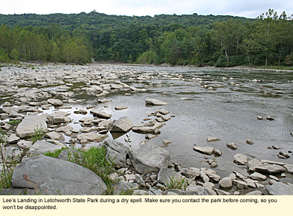
Genesee River (Lee's Landing to St. Helena)
Class: II-III
Distance: 4.5 mi./7.2 km.
Put-in Location: 42.59419ºN 78.00493ºW
Take-out Location: 42.62024ºN 77.98797ºW
Note: Located in Letchworth State Park. Canoers and kayakers must register with the park. Participants must be experienced whitewater paddlers and good swimmers. Those under 18 years of age must be accompanied by an adult. See also: http://www.letchworthpark.com/generalinfo.htm and http://www.ilovethefingerlakes.com/rivers/genesee-part2.htm.
Nearby: Keshagua Creek
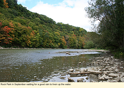
Genesee River (Rock Park)
Class: I-III+
Distance: .5 mi./8 km.
Put-in Location: 43.18673°N 77.62611°W
Take-out Location: Same as above
Note: This site of located below (in elevation) the parking area on Seth Green Dr. in the City of Rochester. You will need to park and carry your equipment down a paved road to the water's edge. Physically situated just below (north) of the Lower Falls, this spot provides year-round whitewater. You can continue to paddle all the way downstream (north) to Lake Ontario if you choose. For more information about this section of the Genesee, click here.
Nearby: Irondequoit Creek
Honeyoe Creek
Class: II-III
Distance: 4 mi./6.4 km.
Put-in Location: 42.54ºN 77.33001ºW
Take-out Location: 42.94527ºN 77.58354ºW
Irondequoit Creek
Class: II (III)
Distance: .5 mi./.8 km.
Put-in Location: 43.12612ºN 77.48165ºW
Take-out Location: 43.12735ºN 77.49029ºW
Nearby: Erie Canal
Keshegua Creek
Class: II+
Distance: 7 mi./11.2 km.
Put-in Location: 42.63752ºN 77.86632ºW
Take-out Location: 42.68252ºN 77.82837ºW
Nearby: Genesee River in Letchworth State Park, Canasaraga Creek
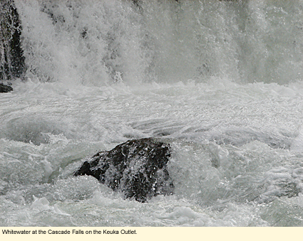
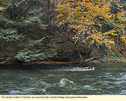
Keuka Outlet Creek
Class: I-III (V+)
Distance: 7.5 mi./12 km.
Put-in Location: 42.65861ºN 77.05389ºW
Take-out Location: 42.68249ºN 76.9564ºW
Note: The Keuka Outlet Creek runs between Keuka and Seneca lakes, dropping 270 ft. along the way. This is a dammed waterway with controlled releases. There is a hiking and biking trail that runs along the creek. The entire outlet area is quite scenic will provide a wealth of recreational opportunities. The put-in location is a small park with no amenities at the intersection of Liberty and East Main steets. For more information about the Outlet Trail, see http://www.keukaoutlettrail.net/index.cfm.
Nearby: Sugar Creek, Genesee River in Letchworth State Park
Oatka Creek
Class: II-III
Distance: 3 mi./4.8 km.
Put-in Location: 42.68252ºN 77.82837ºW
Take-out Location: 43.01576ºN 77.96544ºW
Owasco River
Class: II (III)
Distance: 3 mi./4.8 km.
Put-in Location: 42.93759ºN 76.59401ºW
Take-out Location: 42.9728ºN 76.6002ºW
Note: Owasco River is the outlet of Owasco Lake and runs through the City of Auburn.
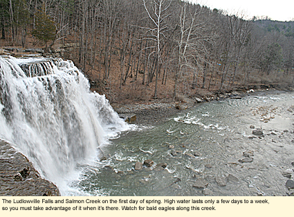
Salmon Creek (Ludlowville Falls to Cayuga Lake)
Class: II
Distance: 2 mi./3.2 km.
Put-in Location: 42.55472ºN 76.53723ºW
Take-out Location: 42.5373ºN 76.5494ºW
Note: Park at the Ludlowville Falls Park and portage down a narrow and sometimes slippery path. Exit at Myers (Point) Park just before the creek enters Cayuga Lake. For more information on this location, click here.
Nearby: Cascadilla Creek, Fall Creek, Six Mile Creek, Taughannock Creek
Six Mile Creek (Rt. 79 to Brooktondale)
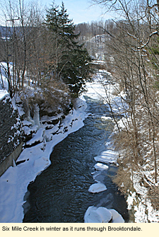 Class: V Class: V
Distance: 3 mi./4.8 km.
Put-in Location: 42.40259ºN 76.43561ºW
Take-out Location: 42.38199ºN 76.38701ºW
Note: For more information about this location, click here.
Nearby: Cascadilla Creek, Fall Creek, Salmon Creek, Taughannock Creek
Sugar Creek
Class: IV-V
Distance: 1.7 mi./2.7 km.
Put-in Location: 42.5511ºN 77.83001ºW
Take-out Location: 42.48222ºN 77.73723ºW
Note: Sugar Creek is the headwaters to Canaseraga Creek.
Nearby: Canaseraga Creek, Keshegua Creek
Taughannock Creek (Podunk Rd. to Rt. 96 Bridge)
Class: II-III+ (IV)
Distance: 2 mi./3.2 km.
Put-in Location: 42.52909ºN 76.6605ºW
Take-out Location: 42.52959ºN 76.6373ºW
Nearby: Cascadilla Creek, Fall Creek, Salmon Creek, Six Mile Creek
Taughannock Creek (Rt. 96 to Upper Falls)
Class: II-III
Distance:1 mi./1.6 km.
Put-in Location: 42.52909ºN 76.63111ºW
Take-out Location: 42.53499ºN 76.6121ºW
Note: This part of the creek is located in Taughannock Falls State Park. For more information about the park, click here.
Nearby: Cascadilla Creek, Fall Creek, Salmon Creek, Six Mile Creek
Updated 16 August 2011
|
