- Site Indexes
- Search by Keyword
- Search by Topic
- Search by Place
- Things to Do
- Entertainment
- Recreation
- History
- Basics
- Accommodations
- Have Some Fun
- Fun Stuff
- Kid Stuff
- Food and Recipes
- Send a Postcard
- Wallpaper
- Our Site
- Site Info
- Contact Us
- Home

xxxx
xxx

x
Home > Recreation > CanalsPlaces to Visit Along the Erie Canal(listed from west to east) BrockportLeave the canal at the Welcome Center at Harvester Park, the site where, in 1846, the first 100 McCormick reapers were manufactured by the Morgan and Seymour foundry. Cyrus Adams BasinSmall, private, and quiet, the hamlet of Adams Basin has changed little since the days when packet boats plied the waters of the Erie Canal. You can rest on the porch of the Adams Basin Inn that overlooks the Canal. This was originally a tavern and is now a bed and breakfast. SpencerportThe Village of Spencerport has a population of 3,500. Originally named Spencer's Basin after one of its first residents, Daniel Spencer, the name was changed to Spencerport as the Canal began to prosper. As a bustling port, it had all the shops necessary to accommodate traffic along the Canal. Today Spencerport's main focus is canal tourism. The Village provides quiet, shady, tree-lined streets just 10 mi./16 km. west of Rochester. It hosts a summer concert series, Spencerport Canal Days at the end of July, and a Fireman's carnival in June. Be sure to visit the Village of Spencerport Depot and Canal Museum at 16 East Avenue during the day and have dinner on the Rose Lummis, the local tour boat, at night. RochesterNo trip along the Canal would be complete without a stop at Rochester, the third largest city in the state and
To access Rochester from the Erie Canal, one can hike/bike the Genesee River Trail, from where the Genesee meets the Erie, into Rochester through the Genesee Valley Park, designed by landscape architect Frederick Law Olmsted. It is roughly 10 mi./15 km. from the Erie into downtown Rochester.
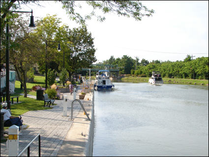
If coming by boat, one can dock at the Corn Hill Landing for the day. Because of the waterfalls along the Genesee, boats can't travel further than Corn Hill. In addition, there are currently no boating facilities at Corn Hill. These can be found along the Canal at Fairport to the east of Rochester. The Corn Hill district of Rochester, however, does provide a wealth of interesting things to do and see and is worth the day trip. PittsfordJust east of Rochester is Pittsford. At Lock 32 you will find one of the U.S. Olympic Kayaking Team's training centers. The Town of Pittsford has a number of parks that offer hiking trails, playing fields, tennis, basketball and handball courts, a jogging and fitness loop, canal access, a launch site for canoes or kayaks, playgrounds, lodges, and beautiful views of the community and its green spaces. The Village of Pittsford, established in 1789, offers a walking tour of its many historic sites. See a description of the sites, including the former home of landscape architect Fletcher Steele and a map. Bushnell's BasinA haven for travelers, Bushnell's Basin has a gourmet café and numerous boutiques that line the canal. But the hamlet is noted most for its topography. The Irondequoit Creek runs through this valley. In order for the Canal to cross the creek without impeding it, the Canal had to go over the creek. To that end, 70-ft./21.3-m. high embankments were built to support a cement channel that spans the entire valley. Guard gates can be closed in the winter to drain the Canal or to stop a flood from breeching Canal walls. FairportFairport is often referred to as the "Crown Jewel of the Erie Canal." Here you will find the only slanted lift bridge
The Village has three canal-side parks--Kennelley Park, Packett's Landing Wharf, and North Bank Canal Park--that provide space to stroll, bike, or just relax. Each June, Fairport’s Canal Days attracts more than 400 arts and crafts exhibitors from all over the United States and tens of thousands of visitors to one of the most anticipated festivals of its kind. Tour boats operate daily throughout the summer. MacedonThe Canalways Trail runs on the north shore at Macedon. The Town has created a trail on the south shore called the Stone Street Trail. Maintained by the Macedon Trails Committee, the entrance to this trail can be found at the end of Stone Street behind the Macedon Elementary School. See a complete description of what can be found along this trail and also a map.
The history of the Canal comes alive at Lock 30 Park in the Village of Macedon where three earlier canal sites can be found. The park also offers picnic areas, a boat ramp, and convenient access to the Village's many shops.
Lock 60 Historic Site is located off Quaker Road between Walworth and O'Neill roads. Here you will find a new floating dock. Lock 60 was opened in 1841 and abandoned in 1914. It is one of the finest surviving locks.
Just west of the O'Neill Road Bridge are the Gallup's Bridge #39 Highway Change Bridge abutments. They are the only known surviving bridge abutments of the enlarged canal. Here, the mules would have changed over from the south side to the north side of the canal. How this was done can be better seen at the Aldrich Change Bridge, which was rescued from the waters of the Ganargua (Mud) Creek in 1997 and installed close to its original location in Aqueduct Park at Lock 29 near the Macedon-Palmyra town line. The Aldrich Change Bridge was manufactured in 1858 by Squire Whipple and provides an example of the Whipple truss design. Not only is it the only surviving change bridge, but it is oldest surviving wrought and cast iron bridge in the state. Also at Aqueduct Park Lock 29 are the Mud Creek Aqueduct and the powerhouse and water channel beneath it. PalmyraPalmyra sports a new marina at the Division Street Bridge, offering boaters improved services, including 10 slips for transient boats. The new marina is part of the Village's historic Canal Street neighborhood, which includes the Towpath Trail, the museums on Market and Williams streets, and the shops on Main Street just one block away. Make sure you visit the Ailing Coverlet Museum at 122 Williams St. to see this country's largest collection of homespun coverlets. At 132 Market St. you'll find the Palmyra Historic Museum in a building that was once a thriving hotel and tavern. Its 23 rooms are filled with all manner of local history.
Every July the Church of Jesus Christ of Latter-Day Saints puts on the enormous nighttime Hill Cumorah Pageant on a hillside outside of Palmyra with a cast of hundreds. It's a spectacle that attracts thousands. Learn more about the Mormon religion with visits to founder Joseph Smith's home, the Peter Whitmer home, the Palmyra Temple, the Sacred Grove, and other related sites. NewarkThe commercial hub of Wayne County, Newark offers a variety of canalside amenities for the boater, including a landscaped canal park, visitor's center, docking facilities, and more. While in Newark, check out the Hoffman Clock Museum at the corner of High and Mason streets and the Newark-Arcadia Historical Society Museum also on High St., which provides a look into local history. The Society also maintains the Marbletown School House, a one-room school built in 1876 located at 6631 Miller Rd. Check with the Historical Society for dates when the school is open for a visit. Word has it that they've just acquired a two-seat outhouse for the school! LyonsNext on your trip east is the Village of Lyons, the Wayne County seat. The silver-domed, white-columned county courthouse--a lovely old structure--can be seen for miles. Never been in jail? Visit the Museum of Wayne County History located in the former jail and sheriff's residence at 21 Butternut St. The building, including the cellblock, is open to the public.
If you see peppermint plants growing along the canal, these herbs are remnants of the peppermint essential oil industry that thrived in the area in the 1800s. So many fields were filled with peppermint plants around Lyons that canallers claimed they could tell when they were reaching the Village by the peppermint scent in the air. The Village holds its Peppermint Days celebration every year in early July.
Abbey Park is just west of the canal lock and has boat docks, a picnic area with grills, and play equipment. Take the path along the Canal from Abbey Park to the Peppermint Office. ClydeFrom Lyons follow the canal parallel to the Clyde River, passed the Galen Wildlife Management Area, to the Village of Clyde. This small village will provide you with any necessities as well as a spot to have a relaxing stroll--Grape Hill Gardens, 1232 Devereaux (Tyre) Rd. The garden, which was filmed by Martha Stewart for her television program, is best in May and June when the lilacs are in bloom. Montezuma National Wildlife RefugeThe canal dips south now through the Montezuma National Wildlife Refuge, a 7,068-acre wetlands complex at the northern end of Cayuga Lake. As the canal flows through the refuge, loops north, and passes by Howland Island, there are numerous opportunities to watch birds and other wildlife. In the spring and autumn huge flocks of migrating birds can be seen. Bald eagles, which breed at Montezuma, can be seen fishing in the large pools. Watch, too, for great blue herons as they stand quietly in shallow water looking for frogs and small fish.
The Erie Canal joins the Seneca River at this point. Upstream, the Seneca River allows you to boat into Cayuga Lake or continue along the river to Seneca Falls, Waterloo, and Seneca Lake. See the Cayuga-Seneca Canal below. Howland IslandAfter leaving the Montezuma NWR, the canal and river split to go around Howland Island, a 3,100-acre state wildlife management area with a mixture of hardwood, second-growth forest, grassland, and wetland. The land is relatively flat, however, there are no paved bike paths. An excellent spot for birding, especially during migration, unmarked dirt paths wind around the island. A compass or GPS system is recommended to prevent getting lost. Cross LakeFollowing the Erie Canal/Seneca River east, they flow into Cross Lake. Cross Lake Park & Campground provides a sandy beach, picnic area, campground, and boat launch. Swimming is permitted in the lake. BaldwinsvilleThe Erie Canal/Seneca River continue to Baldwinsville and Lock 24. With 20,000 lock-throughs a year, it is one of the busiest locks on the canal. Stop by the visitor's center to pick up brochures and maps of the area. If you've come by bike or on foot, you may want to take a tour boat ride on the Emita II docked next to the visitor's center.
The village's newest park is Paper Mill, an island between the Seneca River and the Erie Canal. It has an amphitheater for concerts and festivals, a nature trail on the eastern end of the island that can be accessed from Marble Street, and a picnic area.
While in Baldwinsville, stop by the Museum at Shacksboro Schoolhouse (46 Canton St.) for a variety of local history exhibits. Next to the school is McHarrie Park, a shady place to walk on a warm day. Just off Rt. 370 is Beaver Lake Nature Center. Part of the Onondaga Park System, this 600-acre park has 9 mi./14.4 km. of winding trails and boardwalks through forests, meadows, and wetlands. Canoeing is permitted on the lake. The area's excellent snow cover provides great cross-country skiing and snowshoeing in the winter. Klein IslandHeading east, the Erie Canal/Seneca River splits around Klein Island at the hamlet of Cold Springs. Dipping south of the island, you run into a channel that leads to the northern end of Onondaga Lake, Onondaga Lake Park, and, at the southern end of the lake, the City of Syracuse. Three RiversThe Erie Canal/Seneca River bends northward past the hamlet of Belgium to Three Rivers, so named as it is the confluence of the Seneca, Oneida, and Oswego rivers. Three Rivers is a 3,500-acre state wildlife management area of upland and wetland habits with hiking trails that provide excellent snowshoeing and cross-country skiing in the winter. Birding is usually very good in this area.
The Seneca River ends here, but you can take the Oswego all the way to Lake Ontario or continue east on the Erie Canal/Oneida River. Horseshoe IslandThe Erie Canal/Oneida River flow around the large Horseshoe Island. There are about 170 homes on the island, which is connected to the mainland by a road. This road is considered good for biking and the waters around the island have interesting wildlife habit and are good for canoeing and kayaking. (The boat launch is under the Rt. 481 bridge.) The trip around the island is about 8 mi./12.8 km. Halfway around is a tavern popular with paddlers. If you don't want to go around the island, you can take the Big Ben Cut and continue on east past Glosky Island where the depth is limited. You have the choice of traveling in a northerly direction on the river or taking Anthony Cut directly to Lock 23. This will be your last lock before entering Oneida Lake, the last stop on your trip along the Erie Canal in the Finger Lakes. BrewertonBrewerton was once a fort built around 1759 and strategically placed at the outlet of Oneida Lake. A replica of the blockhouse has been erected. Called the Oliver Stevens Block House Museum, it houses many artifacts of the era. The first settlers came to Brewerton in 1789, opened a fur trading business, and ran a tavern until 1811. By 1865 the area had over 700 inhabitants. Today Brewerton provides services to the many people living around the lake and those who come to enjoy this 21-mi./33.7-km. lake for its natural beauty.
Updated 10 October 2012
|
 McCormick was a resident of Brockport at that time before moving to Chicago. Main Street in Brockport runs over the canal. Why not walk or ride through this lovely rural village and visit its many shops. No need for a map, it's small enough that you won't get lost. Check out Brockport's interesting architecture, starting with the Morgan-Manning House at 152 Main St. Now the home of the
 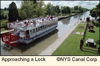 the largest city in the Finger Lakes. Rochester is a cultural center with many fine restaurants, theaters, concert halls, museums, art galleries, parks, and public gardens. Rochester was a stop on the Underground Railroad and was the birthplace of the Women's Rights Movement in this country. It has many fine historic buildings that are open to the public (see the
 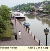 along the Canal. A boater's paradise, it offers modern overnight docking facilities for more than 30 boats in the heart of the Village’s rustic business district. Dockmasters are on duty during the boating season.
|
|