- Site Indexes
- Search by Keyword
- Search by Topic
- Search by Place
- Things to Do
- Entertainment
- Recreation
- History
- Basics
- Accommodations
- Have Some Fun
- Fun Stuff
- Kid Stuff
- Food and Recipes
- Send a Postcard
- Wallpaper
- Our Site
- Site Info
- Contact Us
- Home
xxxx
xxx

x
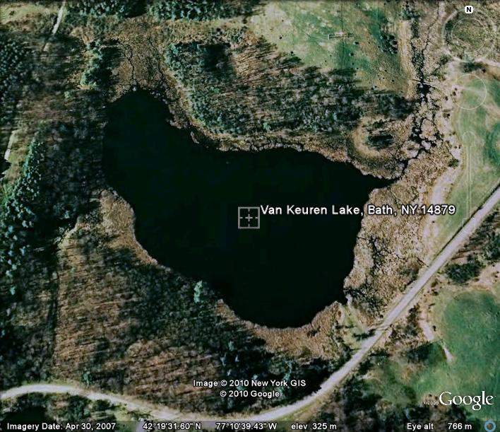
Home > Basics > LakesVan Keuren LakeCoordinates: 42.32563°N 77.17775°W Elevation: 1067 feet/325.2 meters
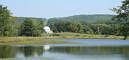
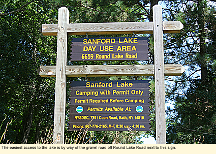
LocationVan Keuren Lake is located on the west side of Round Lake Road in the Steuben County town of Bath just north of the Village of Savona and south of the Hamlet of Sonora. Physical FeaturesVan Keuren Lake is an irregularly shaped glacial lake 6.5 acres in size. It is surrounding on its west side by woods and farmland on the east. AccessAccess is from the Sanford Lake Day Use Area of Birdseye Hollow State Forest (3,446 acres), the entrance to which is on the west side of Round Lake Road. This access road leads to both Sanford and Van Keuren lakes.
To get to Van Keuren Lake, you will need to walk through the steep woods on the right side of the access road about 100 ft./30.4 m. to the shore of the lake. The woods is dry and overgrown in some parts with the non-native Japanese honeysuckle bush and multiflora rose. The lake shore is mucky and overgrown with wetland vegetation. There are no paths to the lake, and locals stated that they knew of no one who went there.
Round Lake is on the east side of Round Lake Road, has public access, and a path.
CampingWilderness camping is permitted at the Sanford Lake Day Use Area at designated campsites by permit only. Portable toilets are provided, but there is no running water or other amenities. BoatingBoats, except those powered by gasoline motors, are permitted on the lake, however, there is really no access to the lake for boats SwimmingAlthough swimming is permitted in theory, there is no beach and access to the water would have to be through the muck at the shore. BikingThe roads in and around the forest are mostly gravel. They are appropriate for mountain bikes and some hybrid bikes, however, in dry weather, road dust may be a problem. State Route 226, off of which Round Lake Road (paved) runs, is good for touring and has paved shoulders. Touring bikes coming from the direction of Savona to the Sanford Lake campground should have no trouble with roads.
Mountain biking is also permitted on the multiple use trail through the forest. Trail map (pdf) HikingThe Finger Lakes Trail runs through Birdseye Hollow State Forest. It doesn't run next to the lake or campground but is within hiking distance of the lake. Trail map (pdf) See also map Horseback RidingHorseback riding is permitted on the multiple use trail in the forest. Trail map (pdf) Winter ActivitiesThere is a specific snowmobile trail in the forest and cross-country skiing and snowshoeing are permitted on the multiple-use trail in the forest. WildlifeBecause Steuben is a large and relatively undeveloped county, it has abundant wildlife, including black bears. The forest is part of a self-guided, forest stewardship demonstration tour. The tour brochure discusses how the forest is being managed and what types of wildlife you can expect to encounter. PhotographyPhotography is good in the area and especially around Sanford Lake. The lake is picturesque and there are plenty of native wildflowers to photograph. Photographing birds is a little difficult as the trees are rather tall and the understory is good. Parks, Forests and Wildlife Management AreasBirdseye Hollow State Forest is next to Moss Hill State Forest (1,815 acres). Nearby, too, is Birdseye Hollow Park on Birdseye Hollow Road in the Town of Bradford (north of Van Keuren Lake). The day-use park has a 68.5-acre pond, a picnic area, a pavilion, and a playground. It is managed jointly by the state and the county. The Finger Lakes Trail runs through the park. Nearby Places of InterestMossy Bank Park and Nature Center AccommodationsBed and breakfasts in Steuben County
Created 1 September 2010
|
|
|